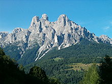
Primiero

The Primiero (Template:Lang-de) is a valley located in the eastern part of Trentino, Italy. It consists of eight municipalities (comuni): Canal San Bovo, Fiera di Primiero, Imèr, Mezzano, Sagron Mis, Siròr, Tonadico and Transacqua.
In Primiero a particular dialect is spoken.[1]
History
This section needs expansion. You can help by adding to it. (February 2013) |
From 1379 until 1918, Primiero was part of the County of Tyrol which, other than a brief period when it was ceded to the Kingdom of Bavaria (1806–1814) during the Napoleonic wars, was ruled by the Austrian Habsburgs (and later their successors the Habsburg-Lorraines). As such it successively formed part of the Habsburg monarchy, the Austrian Empire (from 1804) and, following the compromise of 1867, part of the Cisleithanian (Austrian) territories of Austria-Hungary. It was the capital of the district of the same name, one of the 21 Bezirkshauptmannschaften in Tyrol.[2] It was ceded to Italy along with the rest of Trentino-Alto Adige/Südtirol in the Treaty of Saint-Germain-en-Laye (1919) following Austria-Hungary's defeat in World War I.
See also
References
External links
- Template:It icon Comprensorio di Primiero – Provincia Autonoma di Trento (Retrieved on June 23, 2008)
46°11′N 11°50′E / 46.183°N 11.833°E
