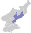
Pujon County
Appearance
Pujon County
부전군 | |
|---|---|
| Korean transcription(s) | |
| • Hanja | 赴戰郡 |
| • McCune-Reischauer | Pujŏn kun |
| • Revised Romanization | Bujeon-gun |
 | |
| Country | North Korea |
| Province | South Hamgyong Province |
Pujŏn County (Pujŏn kun) is a city in northern South Hamgyŏng province, North Korea.
In historical contexts, Pujŏn is sometimes known as Fusen, according to its Japanese pronunciation.
Administrative Divisions
Pujŏn county is divided into 1 ŭp (town), 2 rodongjagu (workers' districts) and 14 ri (villages):
|
|
Transportation
Pujŏn county is served by the Sinhŭng line of the Korean State Railway.

