Pumuta
Appearance
| Pumuta | |
|---|---|
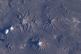
 Jisk'a Kunturiri is located NW of Nevado Sajama (the latter is in the lower center of this NASA image, with north to the top right corner). From left to right there are the snow-covered mountains of Paya Chata, Kunturiri, and Jisk'a Kunturiri and Pumuta (a bit below it to the right ). | |
| Highest point | |
| Elevation | 5,200 m (17,100 ft)[1] |
| Geography | |
| Location | Bolivia, Oruro Department |
| Parent range | Andes |
Pumuta (Aymara puma cougar, puma, uta house,[2] "puma house") is a mountain in the Andes of Bolivia, about 5,200 metres (17,060 ft) high. It is situated in the Oruro Department, Sajama Province, Curahuara de Carangas Municipality, Sajama Canton, north-west of the extinct Sajama volcano.[1][3] Pumuta lies south-west of the mountain Jach'a Kunturiri and north-east to east of the mountains Kunturiri and Jisk'a Kunturiri.
The Kunturiri River originates south of the mountain. It flows to the south and then to the east as a tributary of the Sajama River.
See also
References
- ^ a b BIGM map 1:50,000 Nevados Payachata Hoja 5739-I
- ^ Radio San Gabriel, "Instituto Radiofonico de Promoción Aymara" (IRPA) 1993, Republicado por Instituto de las Lenguas y Literaturas Andinas-Amazónicas (ILLLA-A) 2011, Transcripción del Vocabulario de la Lengua Aymara, P. Ludovico Bertonio 1612 (Spanish-Aymara-Aymara-Spanish dictionary)
- ^ "Curahuara de Carangas". Retrieved September 14, 2014. (unnamed, south-east of Laguna Inca Ingenio)

