Raadhuisstraat
Appearance
You can help expand this article with text translated from the corresponding article in Dutch. (March 2010) Click [show] for important translation instructions.
|


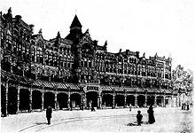
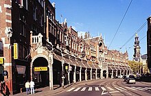
Raadhuisstraat is a street in Downtown Amsterdam, in the Netherlands. It is located between Nieuwezijds Voorburgwal and Prinsengracht. The street is named after the former Town Hall or City Hall, now the Royal Palace and it contains the gallery. It is the main thoroughfare into Old Centre.[1]
Raadhuisstraat was built in 1895.[citation needed] Streets off of Raadhuisstraat are named after the many tanneries that used to be in the area. Th street is noted for its shopping, a shopping area called the "Nine Streets," where vendors sell goods varying from handmade chocolates, high end personal goods and home decorum.[1] A tramline was later introduced.
References
- ^ a b Martin Dunford (2010). The Rough Guide to The Netherlands. Penguin. p. 73. ISBN 978-1-84836-882-8.
52°22′23″N 4°53′16″E / 52.37306°N 4.88778°E
