Rebiana Sand Sea
Appearance
Rabyanah Sand Sea
البحر رمال الربيانا | |
|---|---|
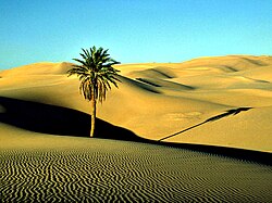
 Phoenix dactylifera Saharan date palm in the Saharan Libyan Desert, Cyrenaica - Southeastern Libya. | |
 Map of the topographic features of the Sahara | |
| Country | Libya |
| Area | |
| • Total | 65,000 km2 (25,000 sq mi) |
| Elevation | 360 m (1,180 ft) |
The Rabyanah Sand Sea, Rabyanah, is a sand desert region in the southeastern sector of Libya with a surface of approximately 65,000 km².[1]
Geography
The area of the Rabyanah Sand Sea is in the western part of the Libyan Desert in the Kufra District of the Cyrenaica region. It is named after the oasis town of Rabyanah located towards its eastern end.
Together with the Calanshio Sand Sea and the Great Sand Sea, the Rabyanah Sand Sea is part of the greater Libyan Desert.[2]
See also
References
- ^ Desert Geomorphology, p. 403
- ^ Besler, Helga (2008) The Great Sand Sea in Egypt: Formation, Dynamics and Environmental Change: A Sediment-Analytical Approach Elsevier, Amsterdam, page 1 - 3, ISBN 978-0-444-52941-1
