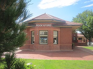
Rocky Ford station
Rocky Ford | ||||||||||||||||
|---|---|---|---|---|---|---|---|---|---|---|---|---|---|---|---|---|
| Former ATSF passenger rail station | ||||||||||||||||
 The station's bay window | ||||||||||||||||
| General information | ||||||||||||||||
| Location | North Main Street at Railroad right-of-way | |||||||||||||||
| Coordinates | 38°03′11″N 103°43′13″W / 38.052995°N 103.720223°W | |||||||||||||||
| Owned by | track owned by BNSF Railway | |||||||||||||||
| Platforms | 1 side platform | |||||||||||||||
| Tracks | 1 | |||||||||||||||
| Construction | ||||||||||||||||
| Structure type | at-grade | |||||||||||||||
| History | ||||||||||||||||
| Opened | 1876 (tracks built)[1] 1903 (current depot built)[2] | |||||||||||||||
| Closed | 1979 | |||||||||||||||
| Services | ||||||||||||||||
| ||||||||||||||||
Rocky Ford Station was an Atchison, Topeka and Santa Fe Railway station in Rocky Ford, Colorado. The station is located two blocks south of U.S. Highway 50 and State Highway 71. The station has been restored and is now used by the Rocky Ford Chamber of Commerce.[3] It was on the Denver Branch, connecting La Junta and Denver. The line is now owned by BNSF.
References
- ^ The History of the Rocky Ford, Colorado Depot. Retrieved March 9, 2011
- ^ Rocky Ford, CO. Retrieved March 21, 2011
- ^ Florence, Mason; Gierlich, Marisa; Dean Nystrom, Andrew (1995). "Eastern Plains". Rocky Mountains. Lonely Planet Publications. p. 358. ISBN 1-86450-327-0.
External links
