
Rome station (Paris Métro)
Rome | |||||||||||
|---|---|---|---|---|---|---|---|---|---|---|---|
| Paris Métro station | |||||||||||
 | |||||||||||
| General information | |||||||||||
| Location | 60, boul. de Batignolles 8th arrondissement of Paris Île-de-France France | ||||||||||
| Coordinates | 48°52′57″N 2°19′19″E / 48.882425°N 2.322052°E | ||||||||||
| Owned by | RATP | ||||||||||
| Operated by | RATP | ||||||||||
| Other information | |||||||||||
| Fare zone | 1 | ||||||||||
| History | |||||||||||
| Opened | 7 October 1902 | ||||||||||
| Services | |||||||||||
| |||||||||||
| |||||||||||

Rome is a station on Paris Métro Line 2 on the border of the 8th and 17th arrondissement of Paris.
The station was opened on 7 October 1902 as part of the extension of line 2 from Étoile to Anvers. The name is that of one of several streets in the area named for European capitals, in this case Rome, capital of Italy.
Nearby are the town hall of the 17th arrondissement and the Institut Universitaire de Formation des Maîtres (teachers' college).
Station layout
| Street Level |
| B1 | Mezzanine for platform connection |
| Platform level | ||
| Westbound | ← | |
| Eastbound | | |
Gallery
-
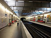 Line 2 platforms at Rome
 -
 Rome station entrance


Wikimedia Commons has media related to Rome (Paris Metro).
References
- Roland, Gérard (2003). Stations de métro. D’Abbesses à Wagram. Éditions Bonneton.
| Stations | |
|---|---|