Jump to content

São Sebastião, Federal District

Coordinates: 15°58′01″S 47°43′37″W / 15.9670°S 47.7270°W / -15.9670; -47.7270
From Wikipedia, the free encyclopedia

This is an old revision of this page, as edited by The Anomebot2 (talk | contribs) at 22:53, 3 June 2016 (Adding geodata: {{coord|15.9670|S|47.7270|W|source:wikidata|display=title}}). The present address (URL) is a permanent link to this revision, which may differ significantly from the current revision.

São Sebastião
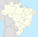
Location of São Sebastião in the Federal District
Country Brazil
RegionCentral-West
State Federal District
Time zoneUTC-3 (UTC-3)
 • Summer (DST)UTC-2 (UTC-2)
Area code+55 61
Websitewww.saosebastiao.df.gov.br

São Sebastião is an administrative region in the Federal District, Brazil.[1]

See also

References

  1. ^ "Geografia – Portal de Brasília". www.brasilia.df.gov.br. Retrieved 2016-05-08.

15°58′01″S 47°43′37″W / 15.9670°S 47.7270°W / -15.9670; -47.7270