Saint Andrew Parish, Saint Vincent and the Grenadines
Appearance
Saint Andrew Parish | |
|---|---|
Parish | |
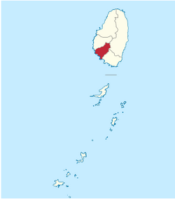
 Map of the Parish of Saint Andrew | |
| Coordinates: 13°12′00″N 061°15′58″W / 13.20000°N 61.26611°W | |
| Country | Saint Vincent and the Grenadines |
| Capital City | Layou |
| Area | |
• Total | 11 sq mi (29 km2) |
| Population | |
• Total | 6,700 |
Saint Andrew is an administrative parish of Saint Vincent and the Grenadines, on the island of Saint Vincent. Its capital is Layou.
- Area: 29 km² (11 mi²)
- Population: 6,700 (2000 estimates)
Populated places
The following populated places are located in the parish of Saint Andrew:[1]
- Camden Park (13°10′21″N 061°14′29″W / 13.17250°N 61.24139°W)[2]
- Chauncey (13°10′N 061°14′W / 13.167°N 61.233°W)
- Clare Valley (13°10′N 061°15′W / 13.167°N 61.250°W)
- Dubois (13°11′N 061°14′W / 13.183°N 61.233°W)
- Edinboro (13°09′35″N 061°14′11″W / 13.15972°N 61.23639°W)[3]
- Francois (13°12′N 061°13′W / 13.200°N 61.217°W)
- Liberty Lodge (13°09′57″N 061°13′54″W / 13.16583°N 61.23167°W)
- Montrose (13°10′N 061°14′W / 13.167°N 61.233°W)
- Pembroke (13°11′N 061°15′W / 13.183°N 61.250°W)
- Questelles (13°10′N 061°14′W / 13.167°N 61.233°W)
- Redemption (13°09′52″N 061°13′46″W / 13.16444°N 61.22944°W)
- Vermont (13°12′N 061°13′W / 13.200°N 61.217°W)
References
- ^ "GeoNames Search". National Geospatial-Intelligence Agency. Retrieved 2 March 2013.
- ^ "Camden Park". Wikimapia. Retrieved 3 March 2013.
- ^ "Edinboro". Wikimapia. Retrieved 3 March 2013.
This article needs additional citations for verification. (March 2013) |
External links
- Parishes of Saint Vincent and the Grenadines, Statoids.com
