Saltstraumen Bridge
Appearance
Saltstraumen Bridge Saltstraumen bru | |
|---|---|
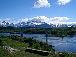
 Saltstraumen with Saltstraumen Bridge and the Børvasstindan mountains | |
| Coordinates | 67°13′51″N 14°36′41″E / 67.23083°N 14.61139°E |
| Carries | |
| Crosses | Saltstraumen |
| Locale | Bodø, Norway |
| Characteristics | |
| Design | Cantilever bridge |
| Material | Concrete |
| Total length | 768 metres (2,520 ft) |
| Width | 11.3 metres (37 ft) |
| Longest span | 160 metres (520 ft) |
| No. of spans | 10 |
| Clearance above | 41 metres (135 ft) |
| History | |
| Construction cost | NOK 25 million[1] |
| Opened | 1977[1] |
| Location | |
 | |
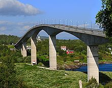
Saltstraumen Bridge (Norwegian: Saltstraumen bru) is a cantilever box girder bridge that crosses the Saltstraumen strait between the islands of Knaplundøya and Straumøya in the municipality of Bodø in Nordland county, Norway.

The bridge is 768 metres (2,520 ft) long, the longest of the 10 spans is 160 metres (520 ft), and the maximum clearance to the sea is 41 metres (135 ft). The bridge is made of prestressed concrete. Saltstraumen Bridge was opened in 1978.[2][3][4]
See also
- List of bridges in Norway
- List of bridges in Norway by length
- List of bridges
- List of bridges by length
References
- ^ a b Aas Jakobsen Reference List, retrieved 9 August 2014
- ^ "Saltstraumen Bridge". Broer.no. Retrieved 2012-03-08.
- ^ Saltstraumen Bridge at Structurae. Retrieved 2012-03-08.
- ^ Merzagora, Eugenio A. (ed.). "Road Viaducts & Bridges in Norway (> 500 m)". Norske bruer og viadukter. Retrieved 2012-03-08.
External links
 Media related to Saltstraumen bru at Wikimedia Commons
- Photo of the bridge
