Salvaterra, Pará
Appearance
Salvaterra | |
|---|---|
Municipality | |
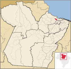
 Location in the State of Pará | |
| Country | |
| Region | North |
| State | |
| Area | |
• Total | 1,043.504 km2 (402.899 sq mi) |
| Elevation | 5 m (16 ft) |
| Population (2008) | |
• Total | 17,077 |
| • Density | 16.8/km2 (44/sq mi) |
| Time zone | UTC-3 (BST) |
| Postal Code | 68860-000 |
Salvaterra is a Brazilian municipality located in the state of Pará. Its population as of 2008 is estimated to be 17,077 people. The area of the municipality is 1,043.504 km². The city is located in the mesoregion Marajó and to the microregion of Arari.


