
Sawtooth Range (Idaho)
| Sawtooth Range | |
|---|---|
 | |
| Highest point | |
| Peak | Thompson Peak |
| Elevation | 10,751 ft (3,277 m) |
| Dimensions | |
| Length | 43 mi (69 km) N/S |
| Width | 25 mi (40 km) E/W |
| Area | 678 sq mi (1,760 km2) |
| Geography | |
 Sawtooth Range | |
| Country | United States |
| State | Idaho |
| Range coordinates | [1] |
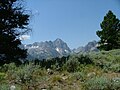
The Sawtooth Range is part of the Rocky Mountains, located within a few miles of Stanley, Idaho, in the Western United States. Much of mountain range is within the Sawtooth Wilderness, part of the Sawtooth National Recreation Area. It encompass an area of 678 square miles (1,756 km2) spanning parts of Custer, Boise, Blaine, and Elmore counties,[2] and is bordered to the east by the Sawtooth Valley.
Thompson Peak (10,751 feet or 3,277 metres) and Mount Cramer (10,716 feet or 3,266 metres) are the range's two highest peaks.[3]
Lakes


(Redfish Lake Creek Canyon)

The Sawtooth Mountains are home to hundreds of lakes created by vanished alpine glaciers. The largest are Redfish Lake, Alturas Lake, Pettit Lake, Yellow Belly Lake, Stanley Lake, and Sawtooth Lake.
Camping
Camping is permitted anywhere in the wilderness. Numerous popular campgrounds exist in the peaks and around the Stanley, Idaho area, including at Redfish Lake and Little Redfish Lake, and Iron Creek near the bottom of the range. Restrictions on fires and animals apply in some areas.
Seismic history
In 2010, scientists from Idaho State University discovered the Sawtooth Fault near the base of the mountains, running for 40 mi (64 km) near Stanley and Redfish Lake. The most recent large quakes along it occurred around 4,000 and 7,000 years ago. It is estimated the fault could produce a 7.5 magnitude earthquake on the Richter scale, potentially felt as far as Boise.[4][5]

Peaks
There are 57 peaks over 10,000' in the Sawtooth Range, all falling between 10,000' and 10,751-foot (3,277 m) Thompson Peak, a remarkable evenness of height. Another 77 fall between 9,000' and 10,000', further evidence of the source of the jagged Sawtooth's name.
Climbs range in difficulty between 9,150' Observation Peak, a Class 1 hike, and 8,980' King Spire, a rock route rated Class 5.10 on the Yosemite Decimal System.
Photos
-
 Wildlife
 -
 Sawtooth Mountains
 -

-
 Sawtooth Mountains and Salmon River
 -
 Redfish Lake from the Boundary Creek


See also
External links
- Sawtooth National Forest - official site
References
- ^ "Sawtooth Range". Geographic Names Information System. United States Geological Survey, United States Department of the Interior. Retrieved 2013-06-23.
- ^ Sawtooth National Forest. “Sawtooth National Forest” [map].1:126,720, 1”=2 miles. Twin Falls, Idaho: Sawtooth National Forest, United States Forest Service, 1998.
- ^ Peakbagger.com - Sawtooth Range. Retrieved 5 March 2007.
- ^ "Scientists find new seismic fault in Rocky Mountains". BBC News. May 20, 2012. Archived from the original on February 12, 2013. Retrieved November 20, 2010.
- ^ Wall, Tim (November 19, 2010). "Large Seismic Fault Found in the Rockies". Discovery News. Archived from the original on February 12, 2013. Retrieved November 20, 2010.