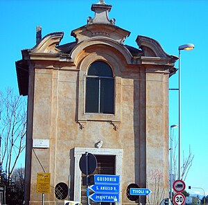
Settecamini
Settecamini is a quarter of Rome, and is the name of the sixth area of the town of Rome in the Agro Romano indicated by Z. VI. It is located in the east of the town near the Grande Raccordo Anulare (Italian for the "Greater Ring Junction") and it borders the town of Guidonia Montecelio. It is part of the Municipio V.
History

The first settlements date back to the Republican era, born around the consular way Via Tiburtina. All neighborhood was a crossroads, as evidenced by the presence of two Roman taverns, but there are also appearances of many Roman villas and tombs.
In medieval times the town was called "Field of Seven Brothers" in relation to the legend of Saint Symphorosa and her seven children (Crescens, Eugenius, Julian, Justin, Nemesius, Primitivus and Stracteus).
Later it was called Oven or Osteria del Forno in reference to the house located in the south of Via Tiburtina, which today is listed as Casale of Settecamini.
A small church, in late Baroque style, was built in 1700 at a crossroads between Via Tiburtina and Via Casal Bianco.
Born as a rural village at the beginning of the twentieth century on lands owned by the Duke Leopoldo di Torlonia, now has an extension of 21.612 km² and a population of 19,000 inhabitants about.
See also
41°56′N 12°38′E / 41.94°N 12.63°E
