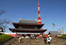
Shiba Park
| Shiba Park | |
|---|---|
 Zōjō-ji and Tokyo Tower | |
 | |
| Location | Minato, Tokyo, Japan |
| Coordinates | 35°39′23″N 139°44′54″E / 35.65639°N 139.74833°E |
| Area | 122,501.09 square metres (30.27068 acres) |
| Created | October 19, 1873 |
Shiba Park (芝公園, Shiba Kōen) is a public park in Minato, Tokyo, Japan built around the temple of Zōjō-ji.
The park is located between the Minato municipal offices and Tokyo Tower. Many of the footpaths in the park offer excellent views of Tokyo Tower, so the park is a popular spot for dates and appears in many television and film sequences. The Central Labor Relations Commission is located here.
Thomas Glover had his Tokyo residence here.
Some of the parkland was once the Ōkubo clan residence in Edo.[1]
Shiba Palace Garden (Shiba Onshi-koen), the grounds of the former Shiba Detached Palace, has become the property of the Municipality and is open to the public.[2] The Arisugawa gardens were purchased by the Imperial Household Agency in 1875. The land has since been donated for public use and enjoyment.[1]
A tree that United States President Ulysses S. Grant planted at the park is still growing there today.
