Shuya (Karelia)
Appearance
| Shuya River | |
|---|---|
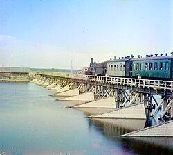
 Early 20th-century photo of a bridge across the Shuya River. | |
 | |
| Physical characteristics | |
| Source | |
| • location | Lake Suoyarvi |
| Mouth | |
• location | Lake Logmozero |
| Length | 194 km (121 mi) |
| Basin size | 10,100 km2 (3,900 sq mi) |
| Discharge | |
| • average | 130 m3/s (4,600 cu ft/s) |
The Shuya River (Template:Lang-fi, also Suoju, Template:Lang-ru) is a river in the Republic of Karelia in Russia. The length of the river is 194 km. The area of its basin is 10,100 km². The Shuya flows out of Lake Suoyarvi and flows through Lake Logmozero into Lake Onega. It freezes up in November - January and stays icebound until April - first half of May.
61°52′43″N 34°17′47″E / 61.8785°N 34.2965°E
