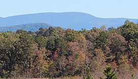
Springer Mountain
This article needs additional citations for verification. (September 2014) |
| Springer Mountain | |
|---|---|
 Springer Mountain viewed from East Ellijay | |
| Highest point | |
| Elevation | 3,780 ft (1,150 m) |
| Coordinates | 34°37′36″N 84°11′37″W / 34.62667°N 84.19361°W |
| Geography | |
 | |
| Location | Fannin / Gilmer counties, Georgia, U.S. |
| Parent range | Blue Ridge Mountains |
| Topo map | USGS Noontootla |
| Climbing | |
| First ascent | unknown |
| Easiest route | Appalachian Trail |
Springer Mountain, part of the Blue Ridge Mountains, is located in the Chattahoochee National Forest in Fannin and Gilmer Counties of northern Georgia. It is now the southern terminus of the Appalachian Trail.
Name
The origin of the name of Springer Mountain is unknown, though the mountain has been called Springer since at least 1910. The most likely possibility is that it was named in honor of William G. Springer, an early settler appointed in 1833 by Governor Lumpkin to implement legislation to improve conditions for the Indians. There is a chance that Springer was named for the first Presbyterian minister to be ordained in Georgia—John Springer—who was ordained in 1790.
As late as 1959, some residents of Gilmer County were still calling the peak Penitentiary Mountain. According to the Gilmer County Historical Society, the name was officially changed by the Georgia Appalachian Trail Club (GATC). Nobody seems to know why it was called Penitentiary—the origin of the name having been lost over time.[1] There is no known Cherokee name for the mountain.
Geography

This section needs expansion. You can help by adding to it. (June 2008) |
The mountain's peak is at 3,780 feet (1,150 m) above mean sea level. It is part of the Blue Ridge Mountains that extend from Georgia to Pennsylvania. Springer divides the northern and southern extensions of the Blue Ridge in Georgia—one branch heading northwest to the Cohutta Mountains, the other southwest to Mount Oglethorpe.[1]
Appalachian Trail

In 1958, the southern terminus of the Appalachian Trail was moved from Mount Oglethorpe approximately 14 miles (23 km) to the northeast to Springer Mountain because of increased development around Mount Oglethorpe. The most popular approach trail to Springer Mountain starts at the visitor's center of Amicalola Falls State Park and is 8.3 miles (13.4 km) in length. It is also common to approach Springer Mountain from a parking lot on Forest Service Road 42, which is 0.9 miles up the Appalachian Trail from the peak of Springer Mountain. Hikers desiring to hike north from Springer Mountain would begin by hiking 0.9 miles south on the Appalachian Trail before turning around to hike north. At the peak of Springer Mountain is a bronze plaque with the Appalachian Trail logo, a register for hikers to sign, and a benchmark. An open-front trail shelter is provided for hikers.
Springer Mountain is included within Ed Jenkins National Recreation Area.[2]
Shelters
Springer Mountain Shelter is located at coordinates (84.19293W, 34.62883N) on a spur trail leading about 70 yards (64 m) east of the Appalachian Trail. Blue blazes mark the spur trail. The trail junction (84.19376W, 34.62880N) is about 800 feet (240 m) north of the brass plaque marking the southern terminus of the Appalachian Trail. The shelter has a raised first floor and a sleeping loft reached by a permanent ladder. Each level of the shelter can comfortably sleep four or five backpackers.
There is a fire circle and wooden picnic table in front (west) of the shelter. There is a three-walled privy down the hill directly behind the shelter. There is a piped spring about 30 yards (25 m) south of shelter. The spring has provided water even in recent drought years. There are two sturdy cables strung in trees near the shelter. Each is equipped with pulleys and hoisting lines for hauling backpacks and food bags out of reach of the local bears, raccoons and rodents.
There is a meadow with room for many tents near the intersection of the Appalachian Trail and the spur trail to the shelter. The meadow also has a fire circle.
The southern terminus of the Benton MacKaye Trail (84.19362W, 34.62963N) is about one hundred yards north of the shelter's spur trail's junction. A bronze plaque honors Benton MacKaye. The plaque is on a rock by the Benton MacKaye Trail a few yards east of the Appalachian Trail.
References
- ^ a b http://www.planetanimals.com/logue/Springer.html
- ^ "Map of the Blue Ridge District, Chattahoochee National Forest" (PDF). U.S. Forest Service. Retrieved 30 April 2012.
