Stadła
Appearance
Stadła | |
|---|---|
Village | |
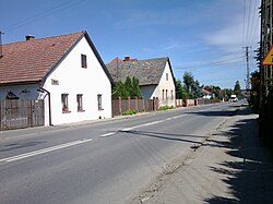
 Buildings of the former German population | |
| Coordinates: 49°35′N 20°37′E / 49.583°N 20.617°E | |
| Country | |
| Voivodeship | |
| County | Nowy Sącz |
| Gmina | Podegrodzie |
| First mentioned | 1469 |
Stadła [ˈstadwa] (before 1964 Stadło) is a village in the administrative district of Gmina Podegrodzie, within Nowy Sącz County, Lesser Poland Voivodeship, in southern Poland. It lies approximately 8 kilometres (5 mi) south-west of Nowy Sącz and 73 km (45 mi) south-east of the regional capital Kraków.[1]
The village was first mentioned in 1469. In 1788 German-speaking Lutheran settled here in the course of Josephine colonization.[2] They built a church that became a religious centre for Lutherans living in other nearby Josephine colonies.
References
[edit]Wikimedia Commons has media related to Stadła (Lesser Poland Voivodeship).
- ^ "Central Statistical Office (GUS) – TERYT (National Register of Territorial Land Apportionment Journal)" (in Polish). 2008-06-01.
- ^ Lepucki, Henryk (1938). Działalność kolonizacyjna Marii Teresy i Józefa II w Galicji 1772-1790 : z 9 tablicami i mapą (in Polish). Lwów: Kasa im. J. Mianowskiego. pp. 163–165.

