
Stathern
Stathern is a village and civil parish in the Melton district of Leicestershire, England. It is in the Vale of Belvoir about 10 miles (16 km) north of Melton Mowbray. In the 2001 census the parish had 288 dwellings,[1] and a population of 672,[2] increasing to 728 at the 2011 census.[3]
-
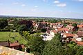
 View of Stathern looking South from the roof of St Guthlac's Church
 -
 View of Stathern looking North from the roof of St Guthlac's Church
 -
 St Guthlac's Church
 -
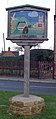
 Signpost in Stathern
 -
 Signpost in Stathern


.jpg)
.jpg)
References
- ^ "2001 Census: Key Statistics: Parish Profile – Accommodation and Tenure: Area: Stathern CP (Parish)". Neighbourhood Statistics. Office for National Statistics. Retrieved 21 November 2009.
- ^ "2001 Census: Key Statistics: Parish Headcounts: Area: Stathern CP (Parish)". Neighbourhood Statistics. Office for National Statistics. Retrieved 21 November 2009.
- ^ "Civil Parish population 2011". Neighbourhood Statistics. Office for National Statistics. Retrieved 21 June 2016.
External links
![]() Media related to Stathern at Wikimedia Commons
Media related to Stathern at Wikimedia Commons
52°51′N 0°51′W / 52.850°N 0.850°W
This Leicestershire location article is a stub. You can help Wikipedia by expanding it. |