Jump to content

Staufenmauer

Coordinates: 50°06′49″N 8°41′13″E / 50.11361°N 8.68694°E / 50.11361; 8.68694
From Wikipedia, the free encyclopedia

This is an old revision of this page, as edited by Cydebot (talk | contribs) at 23:45, 9 December 2016 (Robot - Speedily moving category Visitor attractions in Frankfurt to Category:Tourist attractions in Frankfurt per CFDS.). The present address (URL) is a permanent link to this revision, which may differ significantly from the current revision.

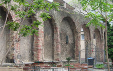
Part of Staufenmauer at Fahrgasse

The Staufenmauer was an old city wall of Frankfurt am Main, Germany.

It was built in 1180 under the Hohenstaufen rule to protect the city from attack and surround the present Altstadt. When the city was expanded in 1333, the old wall became a victim of efforts to reorganize the city defenses.

Today one can still see a small portion along the Fahrgasse, a part that was restored after the 18th century fire in the Jewish Ghetto.

50°06′49″N 8°41′13″E / 50.11361°N 8.68694°E / 50.11361; 8.68694