
Stirling Castle

- For ships named after the castle, see Stirling Castle (disambiguation)
Stirling Castle, located in Stirling, is one of the largest and most important castles, both historically and architecturally, in Scotland. The Castle sits atop the Castle Hill, a volcanic crag, which forms part of the Stirling Sill geological formation. It is surrounded on three sides by steep cliffs, giving it a strong defensive position. Its strategic location, guarding the crossing of the River Forth, has made it an important fortification from the earliest times. The Castle is a Scheduled Ancient Monument, and is managed by Historic Scotland.
History

Most of the principal buildings of the Castle date from the fifteenth and sixteenth centuries. A few structures of the fourteenth century remain, while the outer defences fronting the town date from the early eighteenth century. In the 13th Century Edward I's Scottish campaign included a siege on Stirling Castle. Historians recorded that this was where Warwolf, the largest trebuchet believed built, was first used, with devastating effect.[1][2]
There have been several other sieges of Stirling Castle since the Wars of Scottish Independence, the last being in 1746, when Charles Edward Stuart, "Bonnie Prince Charlie", and his Jacobite force unsuccessfully tried to take the castle. Several Scottish Kings and Queens have been crowned at Stirling, including Mary, Queen of Scots, in 1543.
From 1800 until 1964 the Castle was owned by the British Army and run as a barracks. Many alterations were made to the Great Hall, which became an accommodation block; the Chapel Royal, which became a lecture theatre and dining hall; the King's Old Building, which became an infirmary; and the Royal Palace, which became the Officer's Mess. Efforts to restore all these buildings to their original state are still ongoing. A number of new buildings were also constructed, including the prison and powder magazine, at the Nether Bailey, in 1810. Stirling Castle remains the headquarters of the Argyll and Sutherland Highlanders, although the regiment is no longer garrisoned there. The regimental museum is also located within the castle.
Since January 2002, the Tapestry Studio at West Dean College has been working on a recreation of The Hunt of the Unicorn tapestries. The tapestries will be displayed in the Queen's Presence Chamber at Stirling Castle, part of a project to furnish the Castle as it would have been in the 16th century. Historians studying the reign of James IV believe that a similar series of 'Unicorn' tapestries were part of the royal collection. The team at West Dean Tapestry visited the Cloisters of the Metropolitan Museum of Art, New York City to inspect the originals and researched into medieval techniques, the colour palette and materials. This project is due for completion in 2014. The weavers are working both at West Dean, West Sussex and at Stirling Castle.

The castle
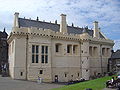
The gatehouse providing entry from the outer defences to the Castle proper was erected by King James IV, and originally formed part of a "fore-front", extending across the whole width of the Rock. At either end of this were rectangular blockhouses, and in the centre, flanking the gateway, were four round towers or "rounds", with conical roofs. Of this composition, there remains the southern blockhouse, or Prince's Tower (now attached to the later Palace), the adjoining length of curtain wall, the gateway and lower portion of the inner rounds, and vestiges of the outer rounds and northern blockhouse.
To the left of the gatehouse, and forming the south side of the principal or upper court, is the Palace block. This was begun by James IV, but is mainly the work of King James V. With its combination of renaissance and late gothic detail, it is one of the most architecturally impressive buildings in Scotland, covered with fine stonework. The ceiling of the King’s Presence Chamber was originally decorated with the famous portrait roundels known as The Stirling Heads, but these were taken down in 1777. Many of them are preserved in the Castle, some in the Smith Institute, Stirling, and others in the National Museum of Antiquities, Edinburgh. There are plans to eventually re-instate the ceiling as close to its original form as possible.
On the east side of the upper court is the Great Hall, built by James IV, and restored to its original appearance in 1999 after many decades' use as a barracks. It is 125 feet long and 36 feet wide, with a completely restored hammerbeam roof, and two oriel windows flanking the dais at the southern end. The small building on its east side is the old Mint, known in Scots as the Cunzie Hoose or "coining house". The renaissance Chapel Royal on the north side of the upper court was built by Master of Works William Schaw for James VI in 1594, for the state christening of his son and heir Prince Henry, on the site of the medieval Chapel Royal.
Modern use
The Castle esplanade, or parade ground, has been used as an open-air concert venue for several noted acts, some of whom have used the Castle and the surrounding scenery to film "in concert" DVDs. Recent acts include R.E.M., Ocean Colour Scene, Bob Dylan, Wet Wet Wet, and Runrig. The esplanade also hosts the city's hogmanay celebrations.
An illustration of the Castle currently features on the reverse side of a current series of £20 notes issued by the Clydesdale Bank, with Robert the Bruce on horseback in the foreground.[3]
Gallery
-
 The Great Hall
 -
 Great Hall interior, facing South.
 -
 Great Hall interior, facing North.
 -
Great Hall wall hanging with James IV's arms
-
 The castle's outer fortifications, looking northward
 -
 Cannon
 -
 Castle gardens
 -
 Stirling Castle at night


References
- ^ NOVA Builds a Trebuchet
- ^ The Warwolf Trebuchet Plans
- ^ "Current Banknotes : Clydesdale Bank". The Committee of Scottish Clearing Bankers. Retrieved 2008-10-30.
External links
- Articles lacking sources from April 2008
- Castles in Stirling council area
- Category A listed buildings
- Listed buildings in Stirling council area
- Listed castles in Scotland
- Royal residences in Scotland
- Scheduled Ancient Monuments in Scotland
- Wars of Scottish Independence
- Buildings and structures illustrated on sterling banknotes
- Volcanic plugs