Stolkertsijver
Appearance
Stolkertsijver | |
|---|---|
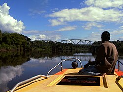
 Bridge spanning the Commewijne river at Stolkertsijver | |
| Country | |
| District | Commewijne District |
Stolkertsijver is a town in the Commewijne District of Suriname. It is situated on the East-West Link. At Stolkertsijver, a bridge spanning the Commewijne River was built in 1980.
The village was named after the Stolkertsijver plantation, also known as Courcabo. The plantation was founded around 1670 and owned by Jeronimo Clifford.
5°45′N 54°45′W / 5.750°N 54.750°W
