
Stone Bridge (Manassas)
Stone Bridge crosses Bull Run at the eastern entrance of the Manassas National Battlefield Park in Manassas, Virginia. The original bridge, built in 1825,[1] was destroyed during the First Battle of Bull Run (First Manassas) on July 21, 1861, the first major land battle of the American Civil War. In 1884,[1] a new bridge, apparently similar to the original design, was built on the site of the old bridge. Modern day U.S. Route 29 crosses Bull Run on a bridge built in the late 1960s downstream of this one.
-
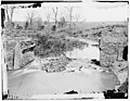 March 1862 photograph of the ruins of the Stone Bridge after the First Battle of Bull Run.
 -
 April 1962 photograph of the late 19th-century bridge built at the location of the original bridge.
.jpg)
.jpg)
Notes
- ^ a b "Places". U.S. National Park Service. Retrieved June 3, 2012.