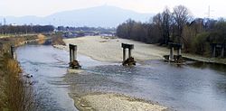
Stura di Lanzo
Appearance

| Stura di Lanzo | |
|---|---|
 The Stura di Lanzo in Turin | |
 Stura location within northwestern Italy | |
| Physical characteristics | |
| Source | |
| • location | Pian della Mussa |
| • elevation | 1,850 m (6,070 ft) |
| Mouth | |
• location | Po in Turin |
• elevation | 209.0 m (685.7 ft) |
| Length | 68.8 km (42.8 mi)[1] |
| Basin size | 885.9 km2 (342.0 sq mi)[2] |
| Discharge | |
| • average | (mouth) 26.1 m3/s (920 cu ft/s)[2] |
| Basin features | |
| Tributaries | |
| • left | Stura di Valgrande, Tesso |
| • right | Stura di Viù, Ceronda |
Stura di Lanzo (Template:Lang-la) is a 65-kilometre (40 mi) long river in north-western Italy (Piedmont). It is formed from several tributaries near Lanzo Torinese. It flows into the river Po in Turin.
The name Stura has Celtic origin: stur, which means "to fall".
Notes and references
- ^ AA.VV. (2004). "Elaborato I.c/5". Piano di Tutela delle Acque - Revisione del 1º luglio 2004; Caratterizzazione bacini Idrografici (PDF). Regione Piemonte. Retrieved 2012-06-05.
{{cite book}}: Cite has empty unknown parameter:|cid=(help) - ^ a b AA.VV. (2004). "Elaborato I.c/7". Piano di Tutela delle Acque - Revisione del 1º luglio 2004; Caratterizzazione bacini Idrografici (PDF). Regione Piemonte. Retrieved 2012-06-05.
{{cite book}}: Cite has empty unknown parameter:|cid=(help)
External links
![]() Media related to Stura di Lanzo at Wikimedia Commons
Media related to Stura di Lanzo at Wikimedia Commons
45°05′44″N 7°43′29″E / 45.0956°N 7.72472°E
