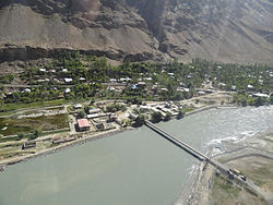
Tajik–Afghan bridge at Tem-Demogan
Tajik–Afghan bridge at Tem-Demogan | |
|---|---|
 Friendship bridge between Afghanistan and Tajikistan Across the Panj river in Region shughnon-shughnan | |
| Coordinates | 37°31′N 71°31′E / 37.52°N 71.51°E |
| Carries | Commercial and passenger vehicles up to 25 metric tonnes |
| Crosses | Panj River |
| Locale | Shughnon, Tajikistan / Shughnan, Afghanistan |
| Characteristics | |
| Design | Suspension bridge |
| Total length | 135 metres |
| Width | 3.5 metres |
| History | |
| Opened | 3 November 2002 |
| Location | |
 | |
The Tajik–Afghan bridge at Tem-Demogan was opened on 3 November 2002.[1][2][3][4] It spans the Panj River. It was the first of four bridges planned to be built with the assistance of the Aga Khan Foundation.
Tem is a microdistrict of Khorugh,[5] in Gorno-Badakhshan Autonomous Province, Tajikistan, which is very sparsely settled. Many of the inhabitants there are Ismaili muslims, followers of the Aga Khan.
Demogan is a location in Afghanistan.
The bridge cost $400,000.[1]
See also
References
- ^ a b "Press Release: Aga Khan and Tajik and Afghan Leaders Open Bridge into Afghanistan". Aga Khan Development Network. 2002-11-03. Retrieved 2008-12-05. mirror
- ^ "Aga Khan and Karzai discuss Afghanistan rehabilitation progress". ReliefWeb. 2002-11-05. Retrieved 2008-12-05. mirror
- ^ "Aga Khan and Tajik and Afghan leaders open bridge into Afghanistan". ReliefWeb. 2002-11-03. Retrieved 2008-12-05.
- ^ "Darwaz Bridge to strengthen commercial ties and Tajik-Afghan relations". Aga Khan Development Network. Retrieved 2008-12-04. mirror
- ^ "Tajikistan building bridge across river to Afghanistan in east"
37°31′27″N 71°30′28″E / 37.52417°N 71.50778°E
Categories:
- Suspension bridges in Tajikistan
- Suspension bridges in Afghanistan
- Afghanistan–Tajikistan border crossings
- Bridges completed in 2002
- 2002 establishments in Tajikistan
- 2002 establishments in Afghanistan
- Asian building and structure stubs
- Tajikistan stubs
- Asian bridge (structure) stubs
- Afghan building and structure stubs
