
Tavurvur
| Tavurvur (Rabaul caldera) | |
|---|---|
 Tavurvur erupting | |
| Highest point | |
| Elevation | 223 m (732 ft) |
| Coordinates | 4°14′20″S 152°12′36″E / 4.239°S 152.21°E |
| Geography | |
 | |
| Location | East New Britain, Papua New Guinea |
| Geology | |
| Mountain type | Stratovolcano |
| Last eruption | 2010[1] |
Tavurvur is an active volcano that lies near Rabaul in Papua New Guinea. It is a sub-vent of the Rabaul caldera[1] and lies on the eastern rim of the larger feature. The volcano is most well known for its devastating eruptions over Rabaul.
Mt Tavurvur is the most well known volcano in Rabaul caldera, and has erupted as recently as January 2009.
History
In 1937, Tavurvur and another nearby volcano, Vulcan, erupted, killing 507 people.
On the 7th of October 2006 the volcano erupted again, and an initial blast shattered windows up to 12 kilometres away and sent an ash plume 18 km into the stratosphere.[2] Fortunately this time winds blew most of the ash away from Rabaul. IM A BO$$ YMCnfsfgfgduyvgruhgruhrubrhubhbrubhrurhburbhrubhrubrubrburbhurbh
Gallery
-
 Space Radar Image of Rabaul Volcano
 -
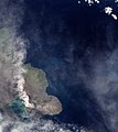
 Tavurvur from space
 -

-
-


References
- ^ a b "Rabaul". Global Volcanism Program. Smithsonian Institution.
- ^ "Winds soften erupting volcano's impact". Online News. Australian Broadcasting Corporation. 2006-10-08.
External links
Wikimedia Commons has media related to Rabaul caldera.