Teisen

Coordinates: 59°54′55.16″N 10°49′3.85″E / 59.9153222°N 10.8177361°E / 59.9153222; 10.8177361
From Wikipedia, the free encyclopedia

This is an old revision of this page, as edited by AlanBOT (talk | contribs) at 14:36, 29 April 2013 (BOT: Fixing overprecise coordinates. Decimal degrees to 6 decimal places; Seconds (from DMS) to 2 decimal places.). The present address (URL) is a permanent link to this revision, which may differ significantly from the current revision.

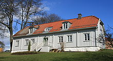
Teisen farm in 2010.
Residential building in Teisen, 2010.

Teisen is a neighborhood in the borough of Alna in Oslo, Norway.

It was a residential area in the 19th century, but from the 1950s it was built up with apartment blocks.[1]

References

  1. ^ Henriksen, Petter, ed. (2007). "Teisen". Store norske leksikon (in Norwegian). Oslo: Kunnskapsforlaget. Retrieved 29 January 2010.

59°54′55.16″N 10°49′3.85″E / 59.9153222°N 10.8177361°E / 59.9153222; 10.8177361