Tell Afis
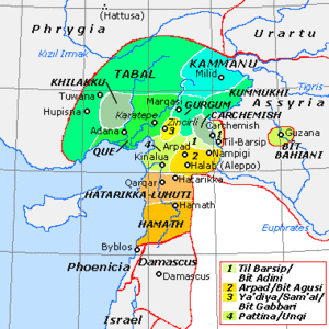
Tell Afis is an archaeological site in the Idlib region of northern Syria, and lies about fifty kilometres southeast of Aleppo.[1] The site is thought to be that of ancient Hazrek (or Hazrach; Hatarikka for the Assyrians) capital of Luhuti.[2][3] Also, this site may have been the ancient Hadrach, mentioned in the Bible.
The Stele of Zakkur, which contains a dedication in Aramaic to the god Iluwer, was discovered here in 1903.
The site has been excavated since 1986 by a joint project from the universities of Rome, Pisa and Bologna, under the direction of Stefania Mazzoni and Serena Maria Cecchini.[4]
The site was reported damaged by encampments during the Syrian civil war.[5]
References
- ^ Venturi, F. (2007) La Siria nell’Età delle Trasformazioni: Nuovi Contributi dallo Scavo di Tell Afis, Cooperativa Libraria Universitaria Editirice Bologna.
- ^ Trevor Bryce. The Routledge Handbook of the Peoples and Places of Ancient Western Asia. p. 296.
- ^ I. E. S. Edwards, Cyril John Gadd, Nicholas Geoffrey Lemprière Hammondpage. The Cambridge Ancient History: Early History of the Middle East. Part 2, Volume 1. p. 282.
{{cite book}}: CS1 maint: multiple names: authors list (link) - ^ Venturi, F. (2007) La Siria nell’Età delle Trasformazioni: Nuovi Contributi dallo Scavo di Tell Afis, Cooperativa Libraria Universitaria Editirice Bologna.
- ^ Cunliffe, Emma., Damage to the Soul: Syria's cultural heritage in conflict, Durham University and the Global Heritage Fund, 1 May 2012
1. Venturi, F. (2007) La Siria nell’Età delle Trasformazioni: Nuovi Contributi dallo Scavo di Tell Afis, Cooperativa Libraria Universitaria Editirice Bologna.

