Taenarum (town)

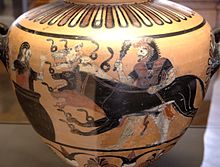
Taenarum or Tainaron (Ταίναρον) or Taenarus or Tainaros (Ταίναρος) was a town of ancient Laconia, situated at the distance of 40 stadia, or 5 miles (8.0 km), north of the isthmus of the Taenarian Peninsula (modern day Cape Matapan). A cavern near Tenarus was considered the entrance to the Greek underworld, through which Heracles dragged Cerberus in his 12th labor, and also through which Orpheus led Eurydice back among the living. Through this association the infernal world was often styled "Tenarus" among classicist writers.[1]
Green marble
[edit]Taenarum was famous for a green marble much prized in the ancient world, as well as the purple snail that yielded the prized Lacedaemonian Purple dye. It was also famous for valuable marble (Latin: Marmor Taenarium), known for its red and black elements.[2]
Seat of a bishop
[edit]Taenarum, was also the seat of a bishop; no longer a resident see, it remains a titular see, suffragan of Corinth, in the Roman Catholic Church.[3]
Location
[edit]Its site is located near the modern Tainaron.[4][5]
References
[edit]- ^ "Tenarus". Encyclopaedia Americana. pp. 188–189.
- ^ Porter, Mary Winearls (1907). What Rome was Built with: A Description of the Stones Employed in Ancient Rome. p. 92.
- ^ Pétridès, Sophron (1912). . Catholic Encyclopedia. Vol. 14.
- ^ Richard Talbert, ed. (2000). Barrington Atlas of the Greek and Roman World. Princeton University Press. p. 58, and directory notes accompanying. ISBN 978-0-691-03169-9.
- ^ Lund University. Digital Atlas of the Roman Empire.
![]() This article incorporates text from a publication now in the public domain: Smith, William, ed. (1854–1857). "Taenarum". Dictionary of Greek and Roman Geography. London: John Murray.
This article incorporates text from a publication now in the public domain: Smith, William, ed. (1854–1857). "Taenarum". Dictionary of Greek and Roman Geography. London: John Murray.
36°24′06″N 22°29′12″E / 36.401551°N 22.4866293°E
