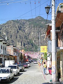
Sierra de Tepoztlan
Appearance
(Redirected from Tepozteco Mountain)


Sierra de Tepoztlan or Tepozteco Mountain is located near the village of Tepoztlán, a Pueblo Mágico, in Morelos, Mexico. The mountain range, "vulnerable to landslides, erosions, and flooding", contains only small areas of land which are appropriate for cultivation.[1] It contains the ruins of a small, pre-Hispanic,[2] Ometochtli temple,[3] known as El Tepozteco. It is believed that there were a number of settlements at one time at the mountain base.[4]
The Sierra is in El Tepozteco National Park, which was established in 1937.[5]
References
[edit]- ^ Marcos 2010, p. 74.
- ^ Sawyer, Kvarnström & Lundberg 2009, p. 24.
- ^ Deane 2011, p. 299.
- ^ Lomnitz 2001, p. 305.
- ^ Urbina Torres, Fernando, Aquiles Argote Cortés, and César D. Jiménez Piedragil (1997). "Protected Areas of Morelos". in Aid, Charles S., Michael F. Carter, and A. Townsend Peterson. Protected Areas of Western Mexico: Status, Management, and Needs. Colorado Bird Observatory, September 1, 1997. Accessed 14 November 2021. [1]
Bibliography
[edit]- Deane, Zain (9 September 2011). Explorer's Guide Mexico City, Puebla & Cuernavaca: A Great Destination (Explorer's Great Destinations). Countryman Press. ISBN 978-1-58157-900-0.
- Lomnitz, Claudio (2001). Deep Mexico, Silent Mexico: An Anthropology of Nationalism. University of Minnesota Press. ISBN 978-0-8166-3289-3.
- Marcos, Sylvia (2010). Women and Indigenous Religions. ABC-CLIO. ISBN 978-0-275-99157-9.
- Sawyer, Maria Lennartsson; Kvarnström, Elisabeth; Lundberg, Tommy (2009). Comparing Sanitation Systems Using Sustainability Criteria. EcoSanRes Programme. ISBN 978-91-86125-12-7.
External links
[edit] Media related to Sierra de Tepoztlán at Wikimedia Commons
19°0′3.28″N 99°6′4.19″W / 19.0009111°N 99.1011639°W
