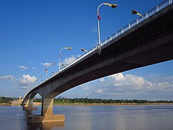
Third Thai–Lao Friendship Bridge
Third Thai–Lao Friendship Bridge | |
|---|---|
 | |
| Coordinates | 17°29′33″N 104°43′42″E / 17.4925°N 104.7283°E |
| Carries | Motor vehicles |
| Crosses | Mekong River, Thai-Lao Border |
| Locale | At Samat, Nakhon Phanom Province, Thailand Thakhek, Khammouane Province, Laos |
| Official name | Third Thai–Lao Friendship Bridge |
| Characteristics | |
| Design | box girder bridge |
| Total length | 1423 m |
| Width | 13 m |
| History | |
| Opened | November 11, 2011 |
| Location | |
 | |
The Third Thai–Lao Friendship Bridge (Thai: สะพานมิตรภาพ ไทย-ลาว แห่งที่ 3, Thai pronunciation: [sàpʰaːn míttràpʰâːp tʰaj laːw hɛ̀ŋ tʰîː sǎːm]) over the Mekong is a bridge that connects Nakhon Phanom Province in Thailand with Thakhek, Khammouane in Laos. The bridge's foundation stone was laid on March 6, 2009, and it opened for traffic on November 11, 2011.[1][2] The bridge is 1423 metres long and 13 metres wide.[3]
The name "Third Thai-Lao Friendship Bridge" was previously also used to refer to the planned bridge from Chiang Khong, Thailand to Huay Xai, Laos, but this bridge is now known as the Fourth Thai-Lao Friendship Bridge.
See also
- Thai-Lao Friendship Bridge
- Second Thai-Lao Friendship Bridge
- Fourth Thai–Lao Friendship Bridge
- Transportation in Laos
- Transport in Thailand
17°29′33″N 104°43′42″E / 17.49250°N 104.72833°E
References
External links
Wikimedia Commons has media related to Third Thai-Lao Friendship Bridge.
