Tiefenhöchstadt
Tiefenhöchstadt is a small village located in Bavaria, Germany. It is in Upper Franconia, in the Bamberg district. Tiefenhöchstadt is a constituent community of Buttenheim.
In 2007, the village had a population of 90.[1]
Geography
A stream called the Deichselbach has its source near Tiefenhöchstadt, and then flows through the village.
The village has an elevation from 449 to 478 meters.
Tiefenhöchstadt lies in the nature park "Naturpark Fränkische Schweiz - Veldensteiner Forst." [2]
History
It is not clear how the name of the small village got the ending -stadt, or city. It is rumored that French soldiers during the Napoleonic Wars traveled to Tiefenhöchstadt, thinking it was a city where they could find accommodation.[3]
Church
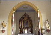
A church in Tiefenhöchstadt was established in 1852; it was the first local chapel. The church has a Neogothic altar.[4] The name of the church is the Kreuzerhöhung, or Holy Cross.[5]
 |
 |
Culture
There are several community organizations in Tiefenhöchstadt:
- Volunteer Fire Department: "FFW-Tiefenhöchstadt" [6]
- Women's Group: "Frauengruppe Tiefenhöchstadt" [7]
References
- ^ Markt Buttenheim - Information Booklet, Page 25. Template:De icon
- ^ Google Maps, Accessed September 20, 2010.
- ^ Markt Buttenheim - Information Booklet, Page 15. Template:De icon
- ^ Buttenheim Website - Tiefenhöchstadt's Neogothic Altar Template:De icon
- ^ Markt Buttenheim - Information Booklet, Page 33. Template:De icon
- ^ Buttenheim Vereinsdatenbank - FFW-Tiefenhöchstadt Template:De icon
- ^ Buttenheim Vereinsdatenbank - Frauengruppe Tiefenhöchstadt Template:De icon
External links
- Google Maps - Tiefenhöchstadt, Accessed September 20, 2010.
- Naturpark Fränkische Schweiz - Veldensteiner Forst, Accessed August 27, 2010. Template:De icon
