Toliara Province
Toliara | |
|---|---|
Province | |
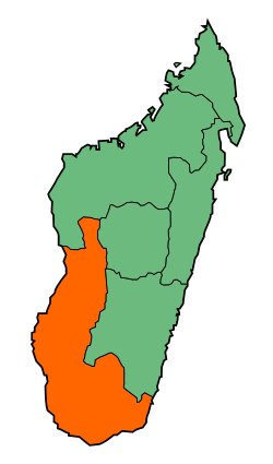
 Map of Madagascar with Toliara highlighted | |
| Country | |
| Capital | Toliara |
| Area | |
• Total | 161,405 km2 (62,319 sq mi) |
| Population (2001) | |
• Total | 2,229,550 |
| • Density | 14/km2 (36/sq mi) |
| Time zone | UTC+3 |
The Toliara Province (formerly Toliary or Tuléar) is a former province of Madagascar with an area of 161,405 square kilometres (62,319 sq mi). It had a population of 2,229,550 (July, 2001). Its capital was Toliara. Near Toliara was the "spiny forest".
Toliara Province bordered the following provinces – Mahajanga Province in the north, Antananarivo Province in the northeast and Fianarantsoa Province in the east. Masikoro Malagasy and Tandroy Malagasy were the chief languages.[1] Sea cucumbers were exported from the province and were an important factor in its economy.[2] The deciduous Andronovory forest was located in the province.[3]
The province was the poorest one in Madagascar. In 1993, 8 in every 10 person of the province was living below the poverty line. Despite the production of export crops the province recorded the highest rural poverty.[4][5] The average fertility rate per woman was above 5.[6] With 77 percent of its population being illiterate, Tolaira was the most illiterate province of Madagascar. Only 22 percent of the province's population had received primary level education.[7][8]
The commercially valuable softwood tree Givotia madagascariensis, found in Antananarivo and Toliara provinces was endemic to Madagascar.[9] The oil producing plant moringa drouhardii was endemic to Toliara province.[10] Deforestation was a major issue for the province.[11] In April 1971, a peasant rebellion was organised by MONIMA leader Monja Joana. The peasants refused to pay taxes and the government retaliated by dissolving MONIMA and deporting Joana.[12]
Toliara province offered poor transport and security facilities.[13][14] Potable water was accessible to only 24.9% of the province's households.[15] It was rich in terms of minerals.[16][17] Toliara province was in the news in July 2005 for its mining activity.[18]
Abolition
The provinces were abolished following the results of Malagasy constitutional referendum, 2007 which led to the formation of 22 smaller areas (faritra or regions) to facilitate regional development.[19]
Administrative divisions

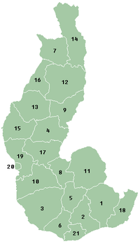
Toliara Province was divided into four regions of Madagascar - Androy, Anosy, Atsimo Andrefana and Menabe. These four regions became the first-level administrative divisions when the provinces were abolished in 2009. They are sub-divided into 21 districts:
- Androy region:
- 2. Ambovombe-Androy
- 5. Bekily
- 6. Beloha
- 21. Tsiombe
- Atsimo-Andrefana region:
- Anosy region:
- Menabe region:
- 7. Belon'i Tsiribihina
- 12. Mahabo
- 13. Manja
- 14. Miandrivazo
- 16. Morondava
References
- ^ Frawley 2003, p. 205.
- ^ Lovatelli & Conand 2004, p. 141.
- ^ Collins & Morris 1985, p. 354.
- ^ International Monetary Fund 1997, p. 47.
- ^ International Monetary Fund 2003, p. 20.
- ^ International Monetary Fund 1997, p. 52.
- ^ International Monetary Fund 1997, p. 53.
- ^ World Bank 2002, p. 50.
- ^ Timbers 2, p. 364.
- ^ van der Vossen & Mkamilo 2007, p. 118.
- ^ Cook 2010, p. 84.
- ^ Political Chronology of Africa 2003, p. 261.
- ^ International Monetary Fund 2003, p. 29.
- ^ International Monetary Fund 2003, p. 32.
- ^ International Monetary Fund 2003, p. 39.
- ^ List of minerals
- ^ Milisenda & Henn 1996, pp. 177–178.
- ^ McKay, David (19 July 2005). "Africa's new mining province". miningmx.com. Retrieved 27 February 2013.
- ^ "Initial result shows "Yes" to revision of constitution in Madagascar". People's Daily Online. 7 April 2007. Retrieved 20 September 2014.
Bibliography
- Collins, N. Mark; Morris, Michael G. (1985). Threatened Swallowtail Butterflies of the World: The IUCN Red Data Book. IUCN. ISBN 978-2-88032-603-6.
{{cite book}}: Invalid|ref=harv(help) - Cook, Jonathan A. (2010). Vulnerable Places, Vulnerable People: Trade Liberalization, Rural Poverty and the Environment. Edward Elgar Publishing. ISBN 978-1-84980-519-3.
{{cite book}}: Invalid|ref=harv(help) - Europa Publications (2003). Political Chronology of Africa. Routledge. ISBN 978-1-135-35666-8.
- Frawley, William (2003). International Encyclopedia of Linguistics. Oxford University Press. p. 205. ISBN 978-0-19-513977-8.
{{cite book}}: Invalid|ref=harv(help) - International Monetary Fund (1997). Madagascar - Recent Economic Developments and Selected Issues. International Monetary Fund. ISBN 978-1-4519-9201-4.
{{cite book}}: CS1 maint: ref duplicates default (link) - International Monetary Fund (2003). Madagascar: Poverty Reduction Strategy Paper. International Monetary Fund. GGKEY:WBCZZ86945A.
{{cite book}}: CS1 maint: ref duplicates default (link) - Lemmens, R.H.M.J.; Louppe, D.; Oteng-Amoako, A.A. Timbers 2. PROTA. ISBN 978-92-9081-495-5.
- Lovatelli, Alessandro; Conand, C. (2004). Advances in Sea Cucumber Aquaculture and Management. Food & Agriculture Org. ISBN 978-92-5-105163-4.
{{cite book}}: Invalid|ref=harv(help) - Milisenda, Claudio C.; Henn, U. (1996). "Compositional characteristics of sapphires from a new find in Madagascar". The Journal of Gemmology. 25. Great Britain: Gemmological Association of Great Britain.
{{cite journal}}: Invalid|ref=harv(help) - van der Vossen, H.A.M.; Mkamilo, G.S. (2007). Vegetable oils. PROTA. ISBN 978-90-5782-191-2.
{{cite book}}: Invalid|ref=harv(help) - Education and Training in Madagascar: Toward a Policy Agenda for Economic Growth and Poverty Reduction. World Bank Publications. 2002. ISBN 978-0-8213-5164-2.
