
Tourula

Tourula is a district of Jyväskylä, Finland and a part of the Kantakaupunki ward.[1] It's located near to the Jyväskylä downtown and separated from it by the river Tourujoki.[1]
Tourula was a residental area for working class, made of wooden single-family houses which were built in the 1910s and 1920s.[2][3] The area was merged into Jyväskylä in 1941, and after that the wooden houses started to decay and they were torn down during the 1970s and 1980s.[2] After that, the appearance of Tourula changed radically.
Gallery
-
 The Kangas area in Tourula.
 -
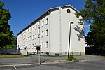 A functional apartment building in Tourula.
 -
 The last wooden house of Tourula. It was torn down in 2015.
 -
 Apartment buildings in Tourula.


References
- ^ a b "Jyväskylän karttapalvelu". kartta.jkl.fi (in Finnish). Retrieved 2018-08-08.
- ^ a b Keskisuomalainen. "Historiallisia kuvia Tourulan puutaloalueelta". KSML.fi – Keskisuomalainen (in Finnish). Retrieved 2018-08-08.
- ^ "Puu-Tourulan henki kertoo alkuperäisestä omakoti-ihanteesta - TS Koti". TS Koti (in Finnish). 2016-01-28. Retrieved 2018-08-08.