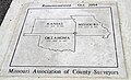
Tri-State Marker

Coordinates: 36°59′55.0″N 94°37′05.2″W / 36.998611°N 94.618111°W / 36.998611; -94.618111
From Wikipedia, the free encyclopedia

This is an old revision of this page, as edited by Nutcase1069 (talk | contribs) at 22:15, 24 September 2017 (Replace coordinates with tri-point of KS, OK, MO (was set to tri-point of OK, MO, AR in 2012); revert text to reflect tri-point of KS, OK, MO (per original article and links)). The present address (URL) is a permanent link to this revision, which may differ significantly from the current revision.

A native stone marker that marks the tri-point at the southeast corner of Kansas, northeast corner of Oklahoma, and western edge of Missouri. It is also called "SE Corner Monument" in Kansas.

More recent surveys have shown the actual tri-point is about 50 feet (15 m) to the southeast where a new marker was placed by the Missouri Department of Natural Resources.

See also

Sources

36°59′55.0″N 94°37′05.2″W / 36.998611°N 94.618111°W / 36.998611; -94.618111