
Trzebież
Trzebież | |
|---|---|
Village | |
 Trzebież (2009) | |
 Trzebież | |
| Coordinates: 53°39′23″N 14°30′30″E / 53.65639°N 14.50833°E | |
| Country | |
| Voivodeship | West Pomeranian |
| County | Police |
| Gmina | Police |
| Population | 2,500 |
| Postal code | 72-020 |
| Area code | +48 091 |
| Website | http://www.trzebiez.pl/ |
Trzebież [ˈtʂɛbjɛʂ] (formerly German Ziegenort) - is a village in the administrative district of Gmina Police, within Police County, West Pomeranian Voivodeship, in north-western Poland, close to the German border.[1] It lies approximately 15 kilometres (9 mi) north of Police and 28 km (17 mi) north of the regional capital Szczecin.
The village has a population of 2,500. It lies on the Szczecin Lagoon, and has a harbour, a marina, a beach and a school of sailing.
History
Before 1945 the area was part of Germany. For the history of the region, see History of Pomerania.
Trzebież, known as Ziegenort to its residents while part of Germany until 1945, became part of Poland after the end of World War II and changed its name to the Polish Trzebież.
Below is a time llne showing the history of the different administrations that this city has been included in.
Political-administrative membership
 1815 - 1866: German Confederation, Kingdom of Prussia, Pomerania
 1866 - 1871: North German Confederation, Kingdom of Prussia, Pomerania
- 1871 - 1918: German Empire, Kingdom of Prussia, Pomerania
 1919 - 1933: Weimarer Republik, Free State of Prussia, Pomerania
 1933 - 1945: Nazi Germany, Pomerania
 1945 - 1946: Enclave Police, (the area reporting to the Red Army)
 1946 - 1952: People's Republic of Poland, Szczecin Voivodeship
- 1952 - 1975: People's Republic of Poland, Szczecin Voivodeship
- 1975 - 1989: People's Republic of Poland, Szczecin Voivodeship
- 1989 - 1998: Poland, Szczecin Voivodeship
- 1999 - Current: Poland, Western Pomerania, powiat Police County, gmina Police
Monuments
- Parish church in Trzebiez (1745)
- Houses from the 19th century
Demography
- The village has a population:
- 1864 - 1823
- 1905 - 1808
- 1925 - 2382
- 1939 - 2660
- 1960 - 1897
- 1972 - 2240
- 2001 - 2000
- 2006 - 2500
-
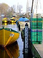 Trzebież, Fish Harbor
 -
 Parish church from 1745
 -
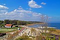 Beach & Promenade Trzebież


Tourism
- PTTK path (green footpath
 Trail Puszczy Wkrzańskiej-Szlak Puszczy Wkrzańskiej) in an area of Trzebież in Wkrzanska Forest
 - Bicycle trail (red
 Trail "Puszcza Wkrzańska"-Szlak "Puszcza Wkrzańska") in an area of Trzebież in Wkrzanska Forest
 - Łarpia Sail Festival
See also
References
- ^ "Central Statistical Office (GUS) - TERYT (National Register of Territorial Land Apportionment Journal)" (in Polish). 1 June 2008.
| Town and seat |  | |
|---|---|---|
| Villages | ||
53°39′23″N 14°30′30″E / 53.65639°N 14.50833°E