Turtle Lake (Tbilisi)
| Turtle Lake Kus Tba კუს ტბა | |
|---|---|
 | |
| Location | Outskirts of Tbilisi |
| Coordinates | 41°42′01″N 44°45′15″E / 41.70028°N 44.75417°E |
| Primary inflows | Varazis-Khevi River |
| Catchment area | 0.4 km² |
| Basin countries | Georgia |
| Surface area | 0.034 km² |
| Max. depth | 2.6 m |
| Surface elevation | 686.7 m |
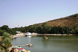
Turtle Lake is a direct English translation of Kus Tba (Georgian: კუს ტბა), a small lake at the outskirts of Tbilisi, the capital of Georgia, so named due to the perceived abundance of turtles living in these places. The other, less frequently used name of this lake is K'ork'i (ქორქის ტბა).
Turtle Lake is located on the wooded northern slope of Mtatsminda Mount at elevation of 686.7 m above sea level and fed by a small river Varazis-Khevi, a tributary to the Mtkvari (Kura). The area of surface is 0.034 km², while the catchment area is 0.4 km². Maximal depth is 2.6 m.
The Turtle Lake area is designed as a recreational zone and is frequented by the Tbilisians on weekends. It is also a place where festivals and concerts are held. It can be reached either via a road or an aerial tramway leading from Tbilisi’s Vake Municipality - this began operating once more in October 2016, is open from 0800 until 2200 and costs 1 lari in each direction. West to the lake is the Open Air Museum of Ethnography, a large exhibition of Georgia’s folk architecture.[1]
See also
References
- ^ Apkhazava, I., "Kus Tba". Georgian Soviet Encyclopedia, vol. 6, p. 88. Tbilisi, 1983. Template:Ka icon
External links
 Media related to Turtle Lake at Wikimedia Commons
