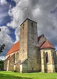
Valjala Parish
Valjala Parish
Valjala vald | |
|---|---|
 Valjala church | |
 Valjala Parish within Saare County. | |
| Country | |
| County | |
| Administrative centre | Valjala |
| Government | |
| • Mayor | Aare Martinson |
| Area | |
| • Total | 180.02 km2 (69.51 sq mi) |
| Population (01.01.2012) | |
| • Total | 1,406 |
| • Density | 7.8/km2 (20/sq mi) |
| Website | www.valjala.ee |
Valjala Parish (or Valjala rural municipality) is a rural municipality in western Estonia. It is a part of Saare County. The municipality has a population of 1,397 (as of 1 January 2006) and covers an area of 180.02 km².
Location
Valjala Parish is situated between Laimjala Parish (east), Pihtla Parish (west) and Leisi Parish (north).
Villages and boroughs
The parish consists of one small borough, Valjala, and 32 villages: Ariste, Jursi, Jõelepa, Jööri, Kalju, Kallemäe, Kalli, Kogula, Koksi, Kuiste, Kungla, Kõnnu, Kõriska, Lööne, Männiku, Nurme, Oessaare, Põlluküla, Rahu, Rannaküla, Röösa, Sakla, Siiksaare, Turja, Tõnija, Undimäe, Vanalõve, Veeriku, Vilidu, Võrsna, Väkra, Väljaküla.
Other features
The parish has 2 schools, kindergarten, and several manors.
The oldest sacral building in Estonia is Valjala church. The construction began in 1227.
See also
External links
- Official website (available only in Estonian).
- Map (Mapquest)


