
Vert-Toulon
-
 Église Saint-Pierre de Vert-la-Gravelle
 -
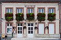 Marie de Vert-Toulon


Vert-Toulon | |
|---|---|
Location of Vert-Toulon  | |
| Country | France |
| Region | Grand Est |
| Department | Marne |
| Arrondissement | Châlons-en-Champagne |
| Canton | Vertus |
| Intercommunality | Région de Vertus |
| Government | |
| • Mayor | Didier Maillard |
| Area 1 | 22.04 km2 (8.51 sq mi) |
| Population (2007) | 303 |
| • Density | 14/km2 (36/sq mi) |
| Time zone | UTC+01:00 (CET) |
| • Summer (DST) | UTC+02:00 (CEST) |
| INSEE/Postal code | 51611 /51130 |
| Elevation | 139–241 m (456–791 ft) (avg. 70 m or 230 ft) |
| 1 French Land Register data, which excludes lakes, ponds, glaciers > 1 km2 (0.386 sq mi or 247 acres) and river estuaries. | |
Vert-Toulon is a commune in the Marne department in north-eastern France. There are 303 residents that live in the village, which are living in 133 homes. There are 159 houses in all, however, the remainder of which are either vacant or vacation housings.[1]
See also
References
Wikimedia Commons has media related to Vert-Toulon.
This Marne geographical article is a stub. You can help Wikipedia by expanding it. |