Villers-sous-Châtillon
Villers-sous-Châtillon | |
|---|---|
Part of Cœur-de-la-Vallée | |
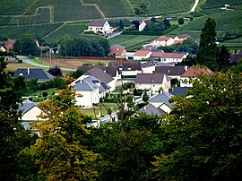
 An aerial view of Villers-sous-Châtillon | |
| Coordinates: 49°05′45″N 3°47′57″E / 49.0958°N 3.7992°E | |
| Country | France |
| Region | Grand Est |
| Department | Marne |
| Arrondissement | Épernay |
| Canton | Dormans-Paysages de Champagne |
| Commune | Cœur-de-la-Vallée |
| Area 1 | 4.84 km2 (1.87 sq mi) |
| Population (2020)[1] | 210 |
| • Density | 43/km2 (110/sq mi) |
| Time zone | UTC+01:00 (CET) |
| • Summer (DST) | UTC+02:00 (CEST) |
| Postal code | 51700 |
| Elevation | 95–255 m (312–837 ft) |
| 1 French Land Register data, which excludes lakes, ponds, glaciers > 1 km2 (0.386 sq mi or 247 acres) and river estuaries. | |
Villers-sous-Châtillon (French pronunciation: [vilɛʁ su ʃatijɔ̃], literally Villers under Châtillon) is a former commune in the Marne department in north-eastern France. On 1 January 2023, it was merged into the new commune of Cœur-de-la-Vallée.[2]
See also[edit]
References[edit]
- ^ "Populations légales 2020" [Legal populations 2020] (PDF) (in French). INSEE. December 2022.
- ^ "Arrêté du 28 septembre 2022 portant création de la commune nouvelle de Cœur-de-la-Vallée". Légifrance. 28 September 2022.
Wikimedia Commons has media related to Villers-sous-Châtillon.


