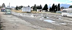
Waiouru railway station
Appearance
Waiouru railway station | |||||||||||
|---|---|---|---|---|---|---|---|---|---|---|---|
 Waiouru railway station in 2018 | |||||||||||
| General information | |||||||||||
| Location | New Zealand | ||||||||||
| Coordinates | 39°28′50″S 175°40′02″E / 39.480659°S 175.667095°E | ||||||||||
| Elevation | 814 m (2,671 ft) | ||||||||||
| Line(s) | North Island Main Trunk | ||||||||||
| Distance | Wellington 290.30 km (180.38 mi) | ||||||||||
| History | |||||||||||
| Opened | 1 March 1907[1] | ||||||||||
| Closed | 10 April 2005[1] | ||||||||||
| Electrified | June 1988 | ||||||||||
| Services | |||||||||||
| |||||||||||
Waiouru railway station in Waiouru, New Zealand was an intermediate station on the North Island Main Trunk line. It was opened for goods traffic in March 1907, and for passengers on 1 July 1908. At 814 m above sea level, the station was the highest station on the New Zealand rail system.

The last passenger train on the NIMT to stop at Waiouru was the Overlander, but from 10 April 2005 it no longer stopped here. The station had been closed for goods traffic on 13 October 1986.
In 1940 a branch was built to the military camp, including a 1,000 ft (300 m) platform.[2] The branch opened on 15 November 1940.[3] It stretched about 2 km (1.2 mi) north east from the station and was still in place in 1966.[4]

References
[edit]- ^ a b Names & Opening & Closing Dates of Railway Stations in New Zealand by Juliet Scoble (2012)
- ^ "Waiouru Camp MANAWATU TIMES". paperspast.natlib.govt.nz. 25 November 1940. Retrieved 5 March 2021.
- ^ Scoble, Juliet (2012). Names & Opening & Closing Dates of Railway Stations in New Zealand.
- ^ "1:63360 map Sheet: N122 Ruapehu". www.mapspast.org.nz. 1966. Retrieved 5 March 2021.
External links
[edit]- 1906 photo of cutting being excavated near Waiouru
- Photo of Royal Mail coach and train
- 1940 photo of station and Ruapehu
