
Whithorn
This article needs additional citations for verification. (April 2008) |

| Whithorn | |
|---|---|
| Population | 867 (2001 Census) |
| OS grid reference | NX445405 |
| Council area | |
| Lieutenancy area | |
| Country | Scotland |
| Sovereign state | United Kingdom |
| Post town | NEWTON STEWART |
| Postcode district | DG8 |
| Dialling code | 01988 |
| Police | Scotland |
| Fire | Scottish |
| Ambulance | Scottish |
| UK Parliament | |
| Scottish Parliament | |
Whithorn (Taigh Mhàrtainn in Gaelic) is a former royal burgh in Wigtownshire Dumfries and Galloway, Scotland, about ten miles south of Wigtown. [1]
The town was the location of the first recorded Christian church in Scotland, Candida Casa : the 'White [or 'Shining'] House', built by Saint Ninian about 397. [2] Whithorn was first known (in Latin) as Candida Casa. 'Whithorn' is a modern form of the Anglo-Saxon version of this name, Hwit Ærne, 'white house'. In Gallovidian Gaelic, it was called Rosnat, or Futarna, the latter a version of the Anglo-Saxon name (Gaelic has no sound corresponding to English 'wh').[3]
"Whithorn" is also the name of the area of 10,000 acres in Wigtownshire, in the District Council Region of Dumfries and Galloway 11 miles south from Wigtown, about eight miles in length, and varies from two to five miles in breadth, anciently divided into baronies, each controlled by a baron of the court of the barony, (i.e. Houston, Baron of the Barony of Busbie or Busby).[4] Scottish feudal barons sat in Parliament by virtue of holding their lands 'per baroniam', that is as barons.[5]
Whithorn's link to the sea was the port known as the Isle of Whithorn (a separate community from Whithorn itself and actually a peninsula). Much used in the Middle Ages by pilgrims arriving by boat.
Rispain Camp, a major Iron Age archaeological site in Scotland
Rispain Camp, one of the major Iron Age archaeological sites in Scotland in the care of Historic Scotland, is located about 1 mile west of Whithorn in the area of Glasserton. It was inhabited between the 200 BC and 200 AD by local Celtic farmers. Its massive rectangular ditch and earthen banks enclosed and protected one or more circular houses and provided a refuge for livestock.[6] Traces of a timber gateway to the north-east would probably have been connected to a timber stockade running along the top of the inner rampart. There were large timber roundhouses inside the enclosure, one of which was thirteen and a half metres in diameter.
Forts and settlements
See Archaeological and Historical Collections relating to Ayrshire and Galloway. vol.V. p.64. "There are ten forts and camps in Whithorn." [7]
Drummoral fort (no photo as yet - Site Name: Drummoral hillfort Map Ref: NX462363 Landranger Map Number: 83 Latitude: 54.698163N Longitude: 4.388104W. (all measurements are approx) A large fort on a rocky ridge which has a narrow flat top 91.4m. long, running east-west with a high rampart fortifying the western portion. Its tallest point is 9.2m. to 12.2m. on the north. It is crossed by two ditches; the inner ditch is 33.5m. long, 9.2m. wide at top, and 2.4m. deep ; the outer ditch is 4.0m. wide. Behind the defences the ridge runs west at two levels each 7.6m. to 12.2m. wide for a distance of about 40.2m. where it then falls away for 18.3m. to 21.3m. to a rocky point. [8] [9]
Iron Age promontory fort, Carghidown. The contour survey, and partial excavation of an Iron Age promontory fort revealed an intermittent succession of roundhouses and an open yard, ultimately enclosed by a rampart and ditch. This rampart appears to have been short–lived (lasting no more than a year or two), and to have been destroyed in a single event, contemporary with the final occupation of the roundhouse, which also appears to have been abruptly abandoned. It is suggested that this may have been result of a violent attack. It is further suggested that the site, given its lack of natural defensibility and secluded location, may have acted as a refuge, in contrast to more prominent fortified sites in the area.[10] [11]
Iron Age promontory fort, Castle Feather with five earthen ramparts and ditches on the north and three on the south. The site was later used for a Tor-Hous or Medieval Castle which had 4ft thick internal walls, with the revetting of the scarp of the inner ditch in stone. [12]
Promontory fort, Cairnhead, Portyerrock Bay. [13]
Steinhead Mote, promontory fort. [14]
Isle Head fort, Isle of Whithorn. [15]
south White Port fort [16]
north White Port fort [17]
Neolithic settlement near Dinnans [18]
Castle Feather fort, Burrow Head [19]
Borough or Burrow Head Cairn A promontory crowned on its southernmost point with a small fort or cairn. 660yards east-northeast there is a natural archway in the cliffs called the Devils Bridge. [20]
The Monastery
5th, 8th & 12th century. A monastery and diocese of the Anglo-Saxon kingdom of Northumbria was founded on the site in the 8th century.
It was the centre of the revived See of Galloway (or Candida Casa) under the patronage of Fergus, Lord of Galloway King of the Kingdom of Galloway Clan MacDowall, and Bishop Gille Aldan from the 12th century.
Whithorn Priory and Museum
The late medieval cathedral Whithorn Priory is ruinous, much of it having disappeared completely apart from the much-altered aisleless nave and vaults at the former eastern end which once held the shrine of St. Ninian, one of medieval Scotland's major pilgrimage destinations.
A museum[21] in the town of Whithorn contains finds from the site, which has been extensively excavated in recent years. A late medieval gateway with the arms of the King of Scots leads into the site of the priory, which contains the 19th-century parish church and a museum of carved stones (Historic Scotland).
Whithorn Museum's collection of early medieval stones is one of the largest in Scotland, and includes the country's earliest surviving Christian memorial, the 5th century inscribed 'Latinus Stone'.
12th century Whithorn crozier, is one of the finest artefacts. The gilded and enamelled crozier is an outstanding example of champlevé enamels which were being made in England in the second half of the 12th century.[22] It is now housed in the National Museums of Scotland, although it is loaned to the Whithorn Trust Visitor Centre [23] every summer. It is thought that the crozier was buried with the body of Simon de Wedale, who was one of the Bishops of Whithorn.
Castle Wig
Castle Wig is noted in "The history of Galloway" vol.II, by William Makenzie, p.70, as being 1 mile N. from the Kirk (Whithorn). It is shown on the map at the beginning of the book. [24] William Agnew of Wigg had Castle Wig. It may also have been known as "Lady Wig".
St Ninian's Chapel
13th century St Ninian's Chapel, Isle of Whithorn, marked the point where pilgrims came ashore (the roofless remains are looked after by Historic Scotland).
It may also have been known as the Kirk of the Inner Isle. [25]
The Robert the Bruce Trail
14th century. The Battle of Loch Ryan was a battle fought on 9/10 February 1307 during the Scottish Wars of Independence near Stranraer on Loch Ryan, Wigtownshire, Galloway, Scotland.
King Robert I of Scotland's invasion of his ancestral lands in Annandale and Carrick began in 1307. The Annandale and Galloway invasion force was led by his brothers Alexander de Brus and Thomas de Brus, Malcolm McQuillan, Lord of Kintyre, an Irish sub king and Sir Reginald de Crawford. The force consisted of 1000 men and eighteen galleys. They sailed into Loch Ryan and landed near Stranraer. The invasion force was quickly overwhelmed by local forces, led by Dungal MacDouall, Clan Macdowall who was a supporter of the Balliols, Comyns and King Edward I of England, and only two galleys escaped. All the leaders were captured. Dungal MacDouall, summarily executed the Irish sub king and Malcolm McQuillan, Lord of Kintyre. Alexander, Thomas and Reginald de Crawford were sent to Carlisle, England, where they were executed. The heads of McQuillan and two Irish chiefs were sent to King Edward I.
See a map of the "The Robert the Bruce Trail" [26]
List of Listed Buildings
List of listed buildings in Whithorn, Dumfries and Galloway
Whithorn gallery
-
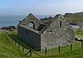
 Whithorn Priory. photo by Stephen McKay
 -
 St Ninian's Priory. photo by Billy McCrorie
 -
 Remains of the Priory Nave at Whithorn. photo by James Allan
 -
 St Ninians Chapel. photo by Van de Beek
 -
 Isle of Whithorn Castle. photo by Roger Griffith
 -
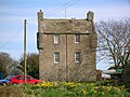
 Castlewigg Tower. photo by Chris Newman
 -
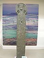 The Monreith Cross in the Whithorn Museum. photo by Roger Griffith
 -
 Iron Age Rispain Camp (Glasserton). photo by Otter
 -
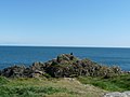 Isle Head, Isle of Whithorn, site of a fort. photo by Billy McCrorie
 -
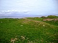 Fort, south White Port. photo by Robert Guthrie
 -
 Fort, north White Port. photo by Richard Law
 -
 Neolithic settlement near Dinnans. photo by Richard Law
 -
 Cairnhead promontory fort. photo by Richard Law
 -
 Stein Head mote. photo by Richard Law
 -
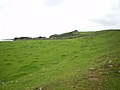
 Carghidown promontory fort. photo by Richard Law
 -
 view towards Castle Feather. photo by Richard Law
 -
 Cairn, Burrow Head. photo by Callum Black


Railway
Whithorn was once served by a railway station until the Beeching axe.
Notes and references
- ^ "Whithorn", Royal Burgh of Whithorn and District Business Association
- ^ Archaeological and Historical Collections relating to Ayrshire and Galloway. vol.VII. pp.53-55
- ^ Thomas, Charles (1971) “Topographical Notes. - 3 : Rosnat, Rostat, and the Early Irish Church” In: Ériu, Vol.xxii, 1971
- ^ Burke's Peerage & Baronetage 106th Edition, Burke's Landed Gentry 19th Edition, Houstoun-Boswall
- ^ 'Barony Title - A Response', Adam Bruce, Journal of the Law Society of Scotland, April 1993, p. 157
- ^ "Rispain", The Whithorn Trust
- ^ Archaeological and Historical Collections relating to Ayrshire and Galloway. vol.V. pp.62-73 http://archive.org/stream/cu31924092901606#page/n115/mode/2up
- ^ http://canmoremapping.rcahms.gov.uk/index.php?action=do_event&event_id=725999&cache_name=aWRudW1saW5rLDYzMDYzX3NlYXJjaHR5cGUsYWR2YW5jZWRfb3Jh&set=0&list_z=0
- ^ http://www.scotlandsplaces.gov.uk/search_item/index.php?service=RCAHMS&id=63063
- ^ http://canmore.rcahms.gov.uk/en/site/63132/details/carghidown+castle/
- ^ http://www.scotlandsplaces.gov.uk/search_item/index.php?service=RCAHMS&id=63132
- ^ http://canmore.rcahms.gov.uk/en/site/63137/details/castle+feather/
- ^ http://canmore.rcahms.gov.uk/en/site/63094/details/cairnhead+mote/
- ^ http://www.gofishing.co.uk/Sea-Angler/Section/wheretofish/Scotland2/Dumfries-and-Galloway/Stein-Head-Sea-Fishing-Mark/
- ^ http://www.ancientmonuments.info/sc1985-isle-head-fort/osmap
- ^ http://www.scotlandsplaces.gov.uk/search_item/index.php?service=RCAHMS&id=174991
- ^ http://www.scotlandsplaces.gov.uk/search_item/index.php?service=RCAHMS&id=174991
- ^ http://www.scotlandsplaces.gov.uk/search_item/index.php?service=RCAHMS&id=174991
- ^ http://canmore.rcahms.gov.uk/en/site/63137/photographs/castle+feather/
- ^ http://jimzglebeblog.blogspot.com.au/2012/07/wigtownshire-ramblers-logan-botanical.html
- ^ "History", The Whithorn Trust
- ^ Glenn, Romanesque and Gothic, pp. 29-33.
- ^ http://www.whithorn.com/whithorn-visitor-attractions-info.asp?rowID=21
- ^ http://archive.org/stream/historyofgallowa02mack#page/n7/mode/2up
- ^ http://geo.nls.uk/search/roy/#zoom=14&lat=54.70126&lon=-4.4054&layers=0B000000TTT
- ^ http://www.sulwathconnections.org/uploads/reports/Leaflet2010.pdf
- Glenn, V. (2003) Romanesque and Gothic: decorative metalwork and ivory carvings in the Museum of Scotland, Edinburgh: Museum
External links
- http://www.aocarchaeology.com/machars/
- http://commons.wikimedia.org/wiki/Category:Whithorn_Priory
- http://archive.org/stream/castellateddomes05macguoft#page/249/mode/1up Castlewigg Tower plan
- http://archive.org/stream/castellateddomes05macguoft#page/354/mode/1up Isle of Whithorn Castle
- The Whithorn Trust
- http://www.whithorn.info/
- http://www.whithornevergreens.co.uk/