Wilder's Folly
| Wilder's Folly | |
|---|---|
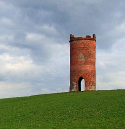
 Wilder's Folly on Nunhide Hill | |
 | |
| Alternative names | Pincent's Kiln, Nunhide Tower and Flint's Folly |
| General information | |
| Type | Folly, belvedere, dovecote |
| Architectural style | Eclectic, neoclassical |
| Location | Sulham, Berkshire, UK |
| Country | United Kingdom |
| Coordinates | 51°26′53″N 1°04′02″W / 51.44819°N 1.06725°W |
| Completed | 1769 |
| Client | Henry Wilder |
Wilder's Folly (also known as Pincent's Kiln, Nunhide Tower and Flint's Folly[1]) is a folly and dovecote at Nunhide, near the village of Sulham in the English county of Berkshire.
History
The simple brick tower was built in 1769 by Reverend Henry Wilder while he was courting Joan, younger sister of John Thoyts of Sulhamstead House.[1] Wilder constructed the belvedere on Nunhide Hill so that it could be seen from Thoyts' home as well as his own residence, Sulham House.
The building featured an open ground-level arcade. The painted first floor room was accessed by an exterior wooden staircase.[1] The two floors above ground level featured glazed ogive windows. The castellated top contained a flat lead roof.[1]
In the late 19th century the building's windows were bricked up and the tower became a dovecote.[1]
The name Wilder's Folly has also been used by a local Reading band from Apr 2018.
Footnotes
Sources
- The Folly Fellowship (2010), "Berkshire Follies" (PDF), Foll-e, no. 27, retrieved 22 December 2010
External links
![]() Media related to Wilder's Folly at Wikimedia Commons
Media related to Wilder's Folly at Wikimedia Commons
