Wisconsin Highway 139
Appearance
| Route information | ||||
|---|---|---|---|---|
| Maintained by WisDOT | ||||
| Length | 24.83 mi[1] (39.96 km) | |||
| Major junctions | ||||
| South end | ||||
| North end | ||||
| Location | ||||
| Country | United States | |||
| State | Wisconsin | |||
| Counties | Forest, Florence | |||
| Highway system | ||||
| ||||


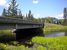
State Trunk Highway 139 (often called Highway 139, STH 139 or WIS 139) is a state highway in the U.S. state of Wisconsin. It runs in north–south in north central Wisconsin from the Michigan State Line and its connection with M-189 at the Brule River approximately four miles north of Tipler in Florence County to a junction with US 8 near Cavour in central Forest County. STH 139 has an approximately three mile long congruence with STH 70 ending roughly one mile west of Tipler. Along its route, STH 139 serves as the main access route to Long Lake and serves parts of the Nicolet side of the Chequamegon-Nicolet National Forest.
References
Wikimedia Commons has media related to Wisconsin Highway 139.
- ^ Bessert, Chris. "Wisconsin Highways: Highways 130-139 (Highway 139)". Wisconsin Highways. Retrieved 2007-03-20.

