
Wli waterfalls
| Wli | |
|---|---|
 Wli Lower Fall | |
 | |
 | |
| Location | Hohoe, Volta Region, Ghana |
| Coordinates | 7°07′29″N 0°35′31″E / 7.124751°N 0.591844°E |
| Type | Chute |
| Total height | 80 meters |
Wli Waterfalls is the highest waterfall in Ghana and the tallest in West Africa.[1] It has a lower and an upper fall.
Location
Wli Waterfalls is located 20 km from Hohoe in the Volta Region of Ghana.[2]
Natural environment
Wildlife
A walk through the forest of the Agumatsa wildlife sanctuary offers a chance to see a large colony of fruit bats, butterflies, birds, monkeys and baboons.[3]
Bats
A large colony of bats can be seen clinging to the cliffs and flying in the sky.[3]
Background
The Wli waterfalls is the highest water fall in West Africa[4] The falls is known locally as Agumatsa waterfalls - meaning, "Allow Me to Flow." It is located in the Hohoe municipality of the Volta Region, the land of the Ewe culture. It is approximately 280 kilometers from the capital Accra.
Gallery
-
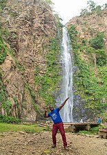
 The falls attracts tourists from all over the world
 -
 The Agumatsa wildlife sanctuary offers a chance to see a large colony of wild fruit bats
 -
 The stunning and mesmerizing nature of the waterfall and the sereneness of the environment


References
- ^ "Wli Waterfall: A Tourist Attraction Worth Visiting". Modern Ghan. Retrieved 21 August 2013.
- ^ "Waterfalls of Ghana". easytrackghana. Retrieved 21 August 2013.
- ^ a b "Photographs of Wli waterfalls in Ghana". Independent Travellers. independent-travellers.com. Retrieved 7 April 2016.
- ^ "Wli Waterfalls". www.bridgingdevelopment.org. Retrieved 2017-04-06.
This Ghana location article is a stub. You can help Wikipedia by expanding it. |