Wolmyeong Park
| Wolmyeongdong Park | |
|---|---|
| Wolmyeong Dong Park | |
| 월명공원 | |
 | |
 | |
| Location | Haemang-dong, Gunsan, North Jeolla Province, South Korea |
| Area | 2.6 square kilometres (1.0 sq mi) |
| Elevation | 16 metres (52 ft) |
| Open | All year round |
| Parking | Available |
Wolmyeong Dong Park, "Wolmyeongdong Park" or "Wolmyeong Park," (Hangul: 월명공원; lit. bright moon park) is a popular tourist destination in the city of Gunsan, South Korea. It serves as an intersecting point where five mountains connect. The total size of the park is 2.6 km² and its longest walking trail is 12 km. It is open all year round.
Things to See
From the top of Susi Tower, which looks like a flame or sail blowing in the wind, you can see all of Gunsan City, the sea to the south of Gunsan, the mouth of the Geum River, and the giant Janghang smelting factory.
At the foot of Seollim Mountain is an old temple named Eunjeoksa. Between Seollim Mountain and Jeombang Mountain is the Jeil Reservoir.
The park also contains an observatory, a sculpture garden, and various monuments.
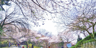
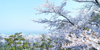
The gardens have been well kept, and 30-year old rattan and cherry trees can be seen.
April Cherry Blossom Photo Contest
The park is especially beautiful during April when the park is covered in cherry blossoms. During that time in April, a cherry blossom photo contest is held at the park.
- Wolmyeong Dong Park Cherry Blossoms in Spring
-
-