
Zolling
Zolling | |
|---|---|
 Coat of arms | |
Location of Zolling within Freising district 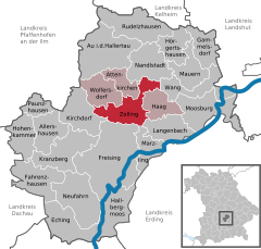 | |
 Zolling  Zolling | |
| Coordinates: 48°27′N 11°46′E / 48.450°N 11.767°E | |
| Country | Germany |
| State | Bavaria |
| Admin. region | Oberbayern |
| District | Freising |
| Municipal assoc. | Zolling |
| Government | |
| • Mayor | Max Riegler |
| Area | |
| • Total | 34.59 km2 (13.36 sq mi) |
| Elevation | 429 m (1,407 ft) |
| Population (2022-12-31)[1] | |
| • Total | 5,051 |
| • Density | 150/km2 (380/sq mi) |
| Time zone | UTC+01:00 (CET) |
| • Summer (DST) | UTC+02:00 (CEST) |
| Postal codes | 85406 |
| Dialling codes | 08167 |
| Vehicle registration | FS |
| Website | www.zolling.de |
Zolling is a municipality in the Bavarian district of Freising. Associated villages are: Anglberg, Flitzing, Thann, Palzing, Oberappersdorf, and Appersdorf.
Zolling lies 6 km to the north of Freising.
Gallery
-
 Zolling power plant
 -
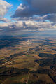 Bird's eye view of Zolling with its power plant
 -
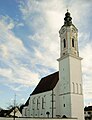 St. John's church in Zolling


References
- ^ Genesis Online-Datenbank des Bayerischen Landesamtes für Statistik Tabelle 12411-003r Fortschreibung des Bevölkerungsstandes: Gemeinden, Stichtag (Einwohnerzahlen auf Grundlage des Zensus 2011) (Hilfe dazu).
Towns and municipalities in Freising (district) | ||
|---|---|---|
 | ||
| International | |
|---|---|
| National | |
This Freising district location article is a stub. You can help Wikipedia by expanding it. |