
Paunküla Reservoir
| Paunküla reservoir | |
|---|---|
 | |
.png) Paunküla reservoir | |
| Location | Kose Parish, Harju County, Estonia |
| Coordinates | 59°06′56″N 25°21′09″E / 59.1156°N 25.3525°E |
| Type | Reservoir |
| Part of | Tallinn water supply system |
| Primary inflows | Paunküla Stream, Palgissaare Stream, Sae-Paunküla Canal |
| Primary outflows | Pirita River |
| Catchment area | 90.1 km2 (34.8 sq mi) |
| Basin countries | Estonia |
| Managing agency | Tallinna Vesi |
| Built | 1960 |
| First flooded | 1960 |
| Max. length | 3.9 km (2.4 mi) |
| Max. width | 1.8 km (1.1 mi) |
| Surface area | 420.2 ha (1,038 acres) |
| Average depth | 3.4 m (11 ft) |
| Max. depth | 8.7 m (29 ft) |
| Water volume | 10,100 m3 (360,000 cu ft) |
| Residence time | 8 weeks |
| Shore length1 | 25.5 km (15.8 mi) |
| Surface elevation | 72.5 m (238 ft) |
| Islands | 22 |
| Settlements | Kiruvere, Ardu |
| References | [1][2] |
| 1 Shore length is not a well-defined measure. | |
Paunküla Reservoir is located in Kiruvere Village, Kose Parish, Harju County, Estonia near Ardu.
The reservoir is part of the Tallinn water supply system and is connected to upstream Jägala river via Sae-Paunküla Canal.
Pirita river runs isolated along the southern shore of the reservoir in a ditch and is only connected to the reservoir at the north-eastern end of the reservoir.[3]
The area of the reservoir is 420 ha (1,000 acres), average depth is 3.4 m (11 ft) and maximum depth is 8.7 m (29 ft).[1]
History
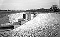
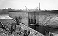
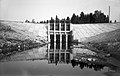
[edit]The reservoir was first flooded in 1960.[3] The reservoir reached its current size in 1979.[2]
Gallery
[edit]- Photos from 1979 reconstruction
-

-

-
-
-
.jpg)
.jpg)
.jpg)
.jpg)
.jpg)
See also
[edit]- Soodla Reservoir
- Raudoja Reservoir
- Aavoja Reservoir
- Kaunissaare Reservoir
- Vaskjala Reservoir
- Lake Ülemiste
- List of lakes of Estonia
References
[edit]- ^ a b "Paunküla veehoidla". keskkonnaportaal.ee (in Estonian). Retrieved 2021-02-04.
- ^ a b "Veekogu: Paunküla veehoidla VEE2031910". infoleht.keskkonnainfo.ee (in Estonian). Retrieved 2021-02-05.
- ^ a b "Paunküla veehoidla". www.eestigiid.ee (in Estonian). Retrieved 2021-02-05.
This Estonia location article is a stub. You can help Wikipedia by expanding it. |