Villamaderne
Appearance
Villamaderne | |
|---|---|
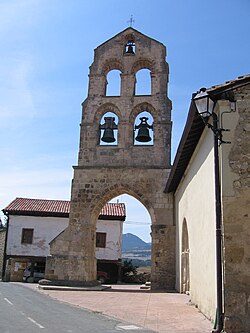
 The bell tower of the parish church of Villamaderne | |
| Coordinates: 42°49′20″N 3°02′28″W / 42.82222°N 3.04111°W | |
| Country | Spain |
| Autonomous community | Basque Country |
| Province | Álava |
| Comarca | Añana |
| Municipality | Valdegovía/Gaubea |
| Area | |
| • Total | 9.74 km2 (3.76 sq mi) |
| Elevation | 550 m (1,800 ft) |
| Population (2023)[2] | |
| • Total | 31 |
| • Density | 3.2/km2 (8.2/sq mi) |
| Postal code | 01423 |
Villamaderne is a hamlet and concejo in the municipality of Valdegovía/Gaubea, Álava province, Basque Country, Spain. The concejo also includes the hamlet of Bellojín.
Heritage
[edit]The parish church is dedicated to San Millán. Originally a Romanesque building, it was substantially reformed by Fausto Íñiguez de Betolaza in the early 20th century. Additionally, there are two chapels in Villamaderne, dedicated to Santa Lucía and Nuestra Señora de la Blanca.
The most notable civil buildings in Villamaderne are the palace-tower and the Venta Blanca, located next to the chapel of Nustra Señora de la Blanca.[3]
References
[edit]- ^ "Divisiones Administrativas SHP Líneas". GeoAraba. Diputación Foral de Álava. 24 January 2024. Retrieved 13 May 2024.
- ^ "Nomenclátor: Núcleos". Entidades Locales de Álava (in Spanish). Diputación Foral de Álava. 1 January 2023. Retrieved 13 May 2024.
- ^ "Villamaderne". Auñamendi Encyclopedia (in Spanish). Eusko Ikaskuntza. Retrieved 13 May 2024.
External links
[edit] Media related to Villamaderne at Wikimedia Commons


