Île Toc Vers
Appearance
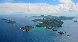
 Île Toc Vers, third island group on left, furthest away in the distance. | |||||||||||||||||||
| Geography | |||||||||||||||||||
|---|---|---|---|---|---|---|---|---|---|---|---|---|---|---|---|---|---|---|---|
| Location | Caribbean | ||||||||||||||||||
| Coordinates | 17°56′35″N 62°49′0″W / 17.94306°N 62.81667°W | ||||||||||||||||||
| Archipelago | Leeward Islands, Lesser Antilles | ||||||||||||||||||
| Adjacent to | Saint Barthélemy Channel | ||||||||||||||||||
| Total islands | 3 | ||||||||||||||||||
| Administration | |||||||||||||||||||
| Additional information | |||||||||||||||||||
| Time zone | |||||||||||||||||||
| |||||||||||||||||||
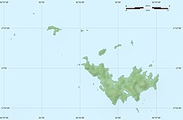
Île Toc Vers is a small island group off the north coast of Saint Barthélemy in the Caribbean.[1] They are the northeasternmost of a series of islands which include Île Chevreau and Île Frégate.[2] The Île Toc Vers group consists of three small rocky islands, aligned in a north–south fashion, between 15 and 43 metres in height. The largest island of the group is in the middle. It is situated within Réserve naturelle nationale de Saint-Barthélemy.
References
[edit]- ^ Île Toc Vers: Guadeloupe National Geospatial-Intelligence Agency, Bethesda, MD, USA
- ^ Adkins, Leonard (1998). The Caribbean: A Walking and Hiking Guide. Hunter Publishing, Inc. p. 141. ISBN 978-1-55650-848-6.


