Chagai Hills: Difference between revisions
| Line 124: | Line 124: | ||
The Chagai Hills terrain is mostly consists of dry desert and located in the northernmost area of [[Chagai District]] at the international [[Durand Line]]– the official name of Afghanistan–Pakistan border.{{rp|45}}<ref name="The Office, 1979"/> |
The Chagai Hills terrain is mostly consists of dry desert and located in the northernmost area of [[Chagai District]] at the international [[Durand Line]]– the official name of Afghanistan–Pakistan border.{{rp|45}}<ref name="The Office, 1979"/> |
||
The Chagai Hills are stretched over an area that is approximately {{convert|130|km|mi}} and {{convert|95|km|mi}}.<ref name="Springer, Valdiya, 2015">{{cite book |last1=Valdiya |first1=K. S. |title=The Making of India: Geodynamic Evolution |date=26 November 2015 |publisher=Springer |isbn=978-3-319-25029-8 |url=https://books.google.com/books?id=BtsLCwAAQBAJ&pg=PA8&dq=Chagai+hills+width&hl=en&sa=X&ved=2ahUKEwiEp8Se1ZqEAxWHCjQIHUTpBRwQ6AF6BAgIEAE#v=onepage&q=Chagai%20hills%20width&f=false |access-date=8 February 2024 |language=en}}</ref> |
|||
=== Topography === |
=== Topography === |
||
Revision as of 02:46, 8 February 2024
This article has multiple issues. Please help improve it or discuss these issues on the talk page. (Learn how and when to remove these messages)
|
| Chagai Hills | |
|---|---|
 The Chagai Hills under the dust storm as seen a photo taken by the ISS Expedition-9 in 2004. | |
| Highest point | |
| Peak | Malik Naru |
| Elevation | 7,915 ft (2,412 m) |
| Dimensions | |
| Length | 130 km (81 mi) |
| Width | 95 km (59 mi) |
| Naming | |
| Defining authority | Geological Survey of Pakistan (GSP) |
| Geography | |
| Region | Balochistan |
| Range coordinates | 29°19′35.65″N 64°6′17.26″E / 29.3265694°N 64.1047944°E |
| Parent range | Toba Kakar |
| Borders on | Durand Line (Pakistan–Afghanistan border) |
| Geology | |
| Mountain type | |
| Type of rock | Granite |
| Climbing | |
| Access | N-40 through Dalbandin |
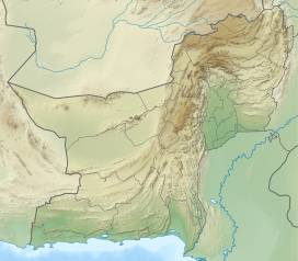
The Chagai Hills is a granite mountain range located in the Chagai District in Balochistan, Pakistan.: 97 [1] The Chagai Hills are separated by the border wall at the Durand Line– the official name of Afghanistan–Pakistan border.: 45 [2]
The highest peak, Malik Naru, at the Chagai Hills is measured at 7,915 feet (2,412 m) and is a site of volcanic Koh-i-Sultan.: 2 [3]: 205 [4]
Overview
Location and topography
During its time as part of the India under the British Queen Victoria, the British Geological Survey conducted the geological survey of the Chagai Hills, which was able to provide its coordinates lies between 28°46′N 63°18′E / 28.767°N 63.300°E in 1908.[5] The more precise coordinates were provided by the extensive geological survey by the Geological Survey of Pakistan (GSP) which provided the coordinates at 29°00′35.65″N 64°00′17.26″E / 29.0099028°N 64.0047944°E in 1983.[1]
The Chagai Hills terrain is mostly consists of dry desert and located in the northernmost area of Chagai District at the international Durand Line– the official name of Afghanistan–Pakistan border.: 45 [2]
The Chagai Hills are stretched over an area that is approximately 130 kilometres (81 mi) and 95 kilometres (59 mi).[6]
Topography
The Chagai Hills are granite mountains, which, at their highest point, rise to a height of 2640 m above sea level. They stretch over an area that is approximately 175 km in length and 95 km in width.
Climate
The Chagai Hills lie in an arid zone, which is outside the main monsoon belt. The region receives an average of 4 inches (102 mm) annually. The temperature is extreme: very hot in summer and very cold in winter. The average minimum temperature is 2.4 °C (36.3 °F) in January and the average maximum temperature is 42.5 °C (108.5 °F) in July.[7]
Nuclear tests
The Chagai Hills were not the location of Pakistan's Chagai-I nuclear tests of 28 May 1998, which were at the Ras Koh Hills, an entirely different range of hills to the south of the Chagai Hills, separated from them by a large valley. However, confusion may arise because widespread reporting prior to the actual explosion mentioned the Chagai Hills region, and because both the Chagai Hills and the Ras Koh Hills are situated in the Chagai District.[7][8]
References
- ^ a b Garren, William R. (1983). Gazetteer of Pakistan: Names Approved by the United States Board on Geographic Names. Defense Mapping Agency. Retrieved 8 February 2024.
- ^ a b Pakistan, a Country Profile. The Office. 1979. Retrieved 8 February 2024.
- ^ Administration Report of the Baluchistan Agency. 1909. Retrieved 8 February 2024.
- ^ Geological Survey Professional Paper. U.S. Government Printing Office. 1977. Retrieved 8 February 2024.
- ^ Ralph Buller; Hughes-Buller (1908). Imperial gazetteer of India: Provincial Series: Baluchistan. Superintendent of government printing. p. 94. Retrieved 28 April 2017.
- ^ Valdiya, K. S. (26 November 2015). The Making of India: Geodynamic Evolution. Springer. ISBN 978-3-319-25029-8. Retrieved 8 February 2024.
- ^ a b "Chagai". Archived from the original on 2019-07-04. Retrieved 2011-07-31.
- ^ "Chagai Hills - Pakistan Special Weapons Facilities".


